Few geographical questions spark as much wonder, curiosity, and bucket-list planning as this one: Where is Mount Everest located?
As the absolute pinnacle of our planet, Mount Everest stands as a universal symbol of human ambition and natural majesty. For trekkers planning their next big adventure, pilgrims seeking spiritual connection, and travelers eager to witness the roof of the world, understanding the exact geography, politics, and accessibility of this legendary peak is the first step toward a successful journey.
We have spent decades guiding global travelers through the high-altitude landscapes of the Himalayas. In this comprehensive, local-expert guide, we will break down the precise location of Mount Everest, demystify the surrounding region, outline key travel routes, and share essential practical insights to help you plan your ultimate Himalayan expedition.
The Exact Geographical Location of Mount Everest
When looking for Mount Everest on a global map, the peak can be traced to the heart of South Asia, nestled within the formidable Himalayan mountain range. This giant chain acts as a dramatic geological barrier separating the Indian subcontinent from the vast Tibetan Plateau.
To be entirely precise, the exact geographic coordinates of the summit are 27°59′17″ N latitude and 86°55′31″ E longitude.
Which Country is Mount Everest In?
A common misconception among first-time travelers is that Mount Everest sits entirely within one nation, or even in neighboring India. The reality is far more fascinating: Mount Everest is located directly on the international border between Nepal and the Tibet Autonomous Region of China.
The border line passes precisely through the summit point. This means that when standing on the very peak of Everest, your left foot could technically be in Nepal while your right foot rests in China.
-
The Southern Face: Belongs to Nepal. Politically, it sits within the Solukhumbu District of Koshi Province.
-
The Northern Face: Belongs to Tibet, China, located in Tingri County within the Shigatse prefecture.
Sub-Ranges and official Height of Mount Everest
Geologically, Everest does not stand alone. It is part of the Mahalangur Himal, a distinct sub-range of the Himalayas that also features three other independent 8,000-meter peaks: Lhotse, Makalu, and Cho Oyu. Following a collaborative, high-precision geodetic and satellite survey conducted by the governments of Nepal and China, the officially recognized height of Mount Everest stands at 8,848.86 meters (29,031.7 feet) above sea level.
Sacred Geography: Names and Local Meaning of Mount Everest
Long before western surveyors labeled the peak "Everest" after Sir George Everest (a British Surveyor General of India), the native communities on both sides of the border revered the mountain as a sacred entity. Understanding these local names offers deep insight into the cultural tapestry of the region.
Sagarmatha (Nepal)
In Nepal, the mountain is known officially as Sagarmatha. Derived from ancient Sanskrit roots, Sagar means "sky" or "heaven," and Matha translates to "head" or "forehead." Thus, Sagarmatha beautifully translates to "The Forehead of the Sky." For the local Nepali people, it represents the ultimate crown of the nation.
Chomolungma / Qomolangma (Tibet)
For the indigenous Sherpas and Tibetan Buddhists who inhabit the northern valleys, the mountain is Chomolungma (frequently spelled Qomolangma). In the Tibetan language, this translates directly to "Mother Goddess of the Universe." The communities believe the mountain is the sacred home of Miyolangsangma, the Buddhist goddess of inexhaustible giving and prosperity. Climbers and trekkers traditionally partake in a Puja (a spiritual blessing ceremony) before stepping foot onto the higher slopes to ask the Goddess for safe passage.
Exploring the Two Sides: Nepal vs. Tibet
Because Mount Everest straddles an international border, adventurers must choose between two distinct geographical approaches. Both entry points offer radically different cultural landscapes, logistics, and visual perspectives.
1. The Southern Approach: Nepal (The Adventurer’s Choice)
The Nepalese side is globally recognized as the most classic, scenic, and culturally immersive way to experience Everest.
The entire southern face is protected within the boundaries of Sagarmatha National Park, a designated UNESCO World Heritage Site renowned for its dramatic deep gorges, pristine glaciers, and unparalleled alpine biodiversity.
-
Landscape: Lush pine and rhododendron forests that slowly transform into rugged, icy moraines as altitude climbs.
-
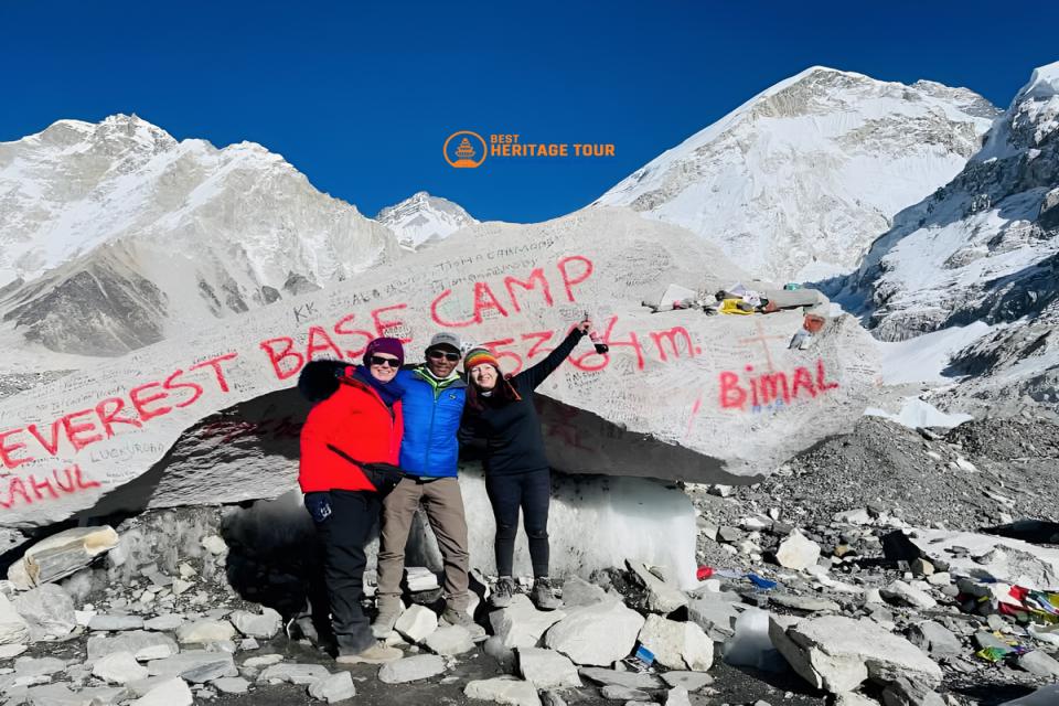
The Experience: Reaching the South Everest Base Camp (EBC) at 5,364 meters requires a multi-day trek. This active immersion allows travelers to acclimatize naturally while walking through iconic mountain villages like Namche Bazaar.
-
Climbing History: This is the legendary route pioneered by Sir Edmund Hillary and Tenzing Norgay Sherpa during their historic first successful ascent on May 29, 1953.
2. The Northern Approach: Tibet, China (The Road-Accessible Route)
The Tibetan side offers a starkly different landscape, characterized by the high-altitude, windswept terrain of the Tibetan Plateau.
-
Landscape: Vast, high-desert plains with immense open vistas, where the North Face of Everest rises sharply as a sheer wall of rock and ice.
-
The Experience: Unlike the Nepalese side, the Northern Base Camp is accessible via a paved road. While this permits travelers to drive directly to the base of the mountain, it poses a much higher risk of acute altitude sickness because visitors ascend rapidly by vehicle rather than trekking progressively.
-
Logistics: Traveling via the northern side requires navigating complex Chinese visa regulations and acquiring specific Tibet Travel Permits, making it less spontaneous for independent international travelers.
How to Get to Mount Everest: Practical Routes from Nepal
For the vast majority of international trekkers and travelers, the journey to Everest begins in Kathmandu, the vibrant capital city of Nepal. We specialize in managing the intricate logistics required to move safely from the city into the deep wilderness of the Khumbu region. Here is exactly how the primary travel routes break down:
Route A: The Classic Everest Base Camp Trek (12 to 14 Days)
This is the definitive global trekking route, balancing physical challenge with rich cultural encounters.
-
The Gateway Flight: You take a short, breathtaking 35-minute flight from Kathmandu (or Manthali airport during peak seasons) to Tenzing-Hillary Airport in Lukla (2,860m).
-
The Footpath: From Lukla, you leave roads behind completely. You walk along well-established paths through Phakding, ascend into the Sherpa capital of Namche Bazaar, and continue past the sacred Tengboche Monastery.
-
The Destination: You trek alongside the massive Khumbu Glacier until you reach Everest Base Camp (5,364m), returning via a hike up Kala Patthar (5,545m) for the most legendary, unobstructed view of the Everest summit.
Route B: Luxury Everest Helicopter Day Tours (3 to 4 Hours)
For travelers who have physical limitations, limited time, or are traveling with young family members, a luxury helicopter tour provides direct access without the physical strain of trekking.
-
The Flightpath: Liftoff from Kathmandu Tribhuvan International Airport early in the morning.
-
The Landing: The flight swoops over the green mid-hills, refuels at Lukla, flies directly over the dramatic Khumbu Icefall, and lands briefly at Kala Patthar or the Everest View Hotel for breakfast surrounded by 8,000-meter peaks.
-
The Benefit: Complete safety and comfort, returning you to Kathmandu by lunchtime with memories to last a lifetime.
When to Visit: Navigating the Seasons
Because of Everest's extreme altitude, weather patterns dictate when it is safe to visit. The region experiences dramatic seasonal shifts that can transform the landscape from an idyllic alpine paradise into a hazardous frozen environment.
|
Season |
Months |
Weather & Visibility |
Ideal For |
|---|---|---|---|
|
Spring (Peak) |
March - May |
Clear mornings, blooming rhododendrons, stable climbing windows. |
Base Camp Treks & Expedition Summits |
|
Autumn (Peak) |
September - November |
Exceptionally crisp, dry air, deep blue skies, brilliant visibility. |
High-altitude trekking and photography |
|
Winter (Off-Peak) |
December - February |
Extreme cold, heavy snow closes high passes, summit winds reach hurricane force. |
Lower altitude treks; highly experienced winter hikers |
|
Monsoon (Off-Peak) |
June - August |
Heavy rainfall, regular cloud cover obscuring views, landslide risks. |
Rare botanical travel; generally avoided for trekking |
Conclusion
Understanding where Mount Everest is located is simply the beginning of the ultimate human adventure. Witnessing the scale of the Mahalangur Himalayas, listening to the flutter of prayer flags in the mountain breeze, and looking up at the iconic South Face of Sagarmatha is a transformative experience that alters your perspective forever.
At Best Heritage Tour, we combine profound local expertise, safety-first high-altitude logistics, and deeply rooted relationships with the Sherpa communities to deliver seamless, awe-inspiring Himalayan journeys. Whether you want to challenge yourself on the classic Everest Base Camp footpath or soar past the peaks on a luxury helicopter excursion, our experienced local guides ensure your safety and comfort every step of the way.
Contact Our High-Altitude Travel Experts Today:
Phone / WhatsApp / Viber: +977-9851149197 / +977-9810043046
Email: info@bestheritagetour.com / bestheritagetour@gmail.com
Website: www.bestheritagetour.com
Office: Thamel Marg, Kathmandu, Nepal
Frequently Asked Questions (FAQ)
Can you see Mount Everest from Kathmandu?
Under exceptionally rare weather circumstances - usually right after heavy monsoon rains when the atmosphere is completely cleared of dust and pollution - the top of Everest can be viewed as a tiny speck on the distant horizon from hills around the Kathmandu Valley like Nagarkot. However, to actually see the iconic mountain clearly, you must fly or trek into the Khumbu region.
Which side of Everest is better for trekking: Nepal or Tibet?
Nepal is widely considered the superior choice for trekking. The southern approach provides an unparalleled cultural immersion into Sherpa villages, stunning trail diversity, and superior infrastructure, including cozy local tea houses and lodges. The Tibet side is largely a drive-in experience across an arid plateau.
Do I need oxygen to trek to Everest Base Camp?
No. Supplementary oxygen is only required for mountaineers climbing above the death zone (7,000m to 8,848m). Everest Base Camp sits at 5,364 meters. While the air is significantly thinner (containing roughly 50% less oxygen than at sea level), a slow, well-paced acclimatization schedule allows healthy trekkers to reach base camp safely without supplemental oxygen.
Author: Best Heritage Tour
Date: 22nd July, 2026