
The Great Himalayan Trail Nepal- 120 Days
Insight on the Great Himalayan Trail
Ever dreamed of exploring all of Nepal’s trekking regions in a single epic journey? If so, the Great Himalayan Trek must be your ultimate choice - covering from Mechi to Mahakali that define the Nepal from East to West. From the majestic Kanchenjunga, Makalu, Everest & Annapurna to legendary passes like Larkya La, Thorong La, Tilman Pass & many more, every step over this four-month, challenges your limits and rewards your spirit. Trek through hidden Sherpa villages, glacial rivers, and untouched landscapes, camping under the stars or resting in cozy teahouses, for an once-in-a-lifetime Himalayan experience.
Trip at a Glance
-

Country: Nepal
-

Trip grade: Very Hard
-

Destination: Himalayas of Nepal
-

Activities: Trekking
-

Accommodation: Teahouse/Camp
-

Meals: Breakfast, Lunch & Dinner
-
.png)
Transportation: Flight & Jeep
-

Maximum altitude: 6,180 m
-

Group size: 1-5
-
Trip Start / End: Kathmandu - Kathmandu
-
.png)
Best Season: Mar, Apr, May & June
Key Highlights
- Complete full east-to-west crossing of Nepal on foot along the legendary Great Himalayan Trail
- Explore Nepal’s most remote and least-traveled regions, far beyond mainstream trekking routes
- Reach Kanchenjunga Base Camp, the world’s third-highest mountain
- Stand at Makalu Base Camp, surrounded by dramatic icefalls and towering peaks
- Cross iconic extreme high passes over 6,000 meters, including Sherpani Col and West Col
- Traverse the heart of the Everest region via classic passes like Cho La, Renjo La, and Amphu Labsta
- Experience sacred Buddhist landscapes in Dolpo, including Shey Gompa and ancient trade routes
- Walk the complete Annapurna Circuit, crossing the famous Thorong La Pass (5,415m)
- Discover the hidden valleys of Manaslu and Ganesh Himal, rich in Tibetan culture
- Visit Rara Lake, Nepal’s largest and most pristine alpine lake
- Trek through Upper Mustang-style terrain in Chharka Bhot and remote trans-Himalayan regions
- Journey across Humla, one of Nepal’s most isolated Himalayan districts
- Cross over 20 major high mountain passes, many rarely trekked or expedition-level
- Witness Nepal’s full ecological range, from lush rhododendron forests to high alpine deserts
- Experience authentic village life in Tibetan-influenced settlements untouched by mass tourism
- Witness the variety of wild animals including Red Panda in Kanchanjunga region & Langtang Region and Snow Leopard in Dolpo region and Mustang region.
Benefits of Booking the GHT with Best Heritage Tour
- Airport pick up and drop off services in a private vehicle are provided at no additional cost
- Convenient booking and reservation process
- Simple payment system
- Multiple communication channels (Email, WhatsApp, Facebook, WeChat, Viber, Skype, Zoom)
- 24/7 phone support at +977-9851149197/+9779810043046
- Provision of first aid kit along with oximeter for monitoring blood oxygen levels at high altitudes
- Provision of sleeping bags and trekking poles if needed
- Duffle bags provided for porters
- Free storage for excess luggage at Best Heritage Tour store during the trek
Trip Overview
The Great Himalayan Trail (GHT) is not merely a trekking holiday; it is the definitive expedition of the 21st century. Spanning 120 days of raw, high-altitude adventure, this full traverse with Best Heritage Tour takes you across the rugged "Spine of the World." This is the only journey on earth where you can witness the sheer diversity of Nepal - from the humid, rhododendron-filled forests of the east to the arid, Tibetan-style plateaus of the far west - all while staying within the shadow of the planet’s highest peaks.
Beginning in the Far East near Kanchenjunga, the trail weaves through pristine forests, deep river gorges, and traditional mountain villages before reaching Kanchenjunga Base Camp. From here, the journey continues westward into the wild and rarely visited Makalu region, where trekkers cross extreme high-altitude passes such as Sherpani Col and West Col, both rising above 6,100 meters. These demanding crossings mark the transition into the legendary Everest region, where classic high passes like Amphu Labsta, Cho La, and Renjo La provide unmatched Himalayan panoramas.
The trail then enters the quieter valleys of Rolwaling, Langtang, and Ganesh Himal, blending dramatic mountain scenery with centuries-old Buddhist culture. As the journey progresses, trekkers complete the iconic Manaslu Circuit, cross Larkya La Pass, and continue into the renowned Annapurna region, culminating with the crossing of Thorong La Pass and a visit to sacred Muktinath.
Beyond Annapurna, the Great Himalayan Trail ventures into the trans-Himalayan landscapes of Mustang and Dolpo, where ancient monasteries like Shey Gompa and remote trade routes reveal a timeless way of life. The Upper Dolpo is also a region of "Crystal Mountains" and turquoise lakes like Phoksundo, where the pre-Buddhist Bon religion still flourishes in isolation. The trek then leads through the tranquil beauty of Rara Lake, before concluding in the isolated highlands of Humla, near the Tibetan border.
Operated by Best Heritage Tour, this expedition-style trek is fully supported with experienced local guides, well-planned acclimatization, and professional logistics. The Great Himalayan Trail is not simply a trek - it is a once-in-a-lifetime Himalayan odyssey designed for seasoned adventurers seeking the ultimate test of endurance, exploration, and cultural discovery. This trek is a rare invitation to join the world’s most exclusive club of explorers.
What to Expect on the Great Himalayan Trail?
1. Extraordinary Geographic Diversity
Expect a visual feast that shifts from the lush, tropical rhododendron forests of eastern Nepal to the stark, lunar-like desert plateaus of the Upper Dolpo. You will traverse every climatic zone imaginable, witnessing the landscape transform from deep river gorges and emerald valleys to the high-altitude glaciers of the "Three Cols" and the West.
2. Diverse Cultural Encounters
As you walk through the heart of Heritage territory, you’ll encounter over 15 distinct ethnic groups. Expect to stay in remote enclaves like Olangchun Gola and Shey Gompa, where ancient Buddhist and Bon traditions remain untouched by time. This trek offers a profound human connection that standard trekking routes simply cannot provide.
3. Extreme High-Altitude Pass Crossings
Expect your world to be defined by the vertical. From the ice-choked Sherpani Col to the legendary Thorong La, the journey is a sequence of grueling ascents followed by euphoric views from the roof of the world. You will learn to breathe with the mountains, finding a steady, meditative pace as you conquer over 30 high-altitude passes.
4. A Masterclass in Himalayan Geology
Witness the raw power of plate tectonics firsthand. Expect to walk across grinding glaciers, navigate deep limestone canyons in Dolpo, and stand atop ridges where the fossils of ancient sea creatures lie thousands of meters above sea level. This is a journey through the very bones of the earth, where every cliffside tells a story of eons.
5. Intimate Encounters with Rare Wildlife
The GHT traverses Nepal’s most pristine National Parks and conservation areas. Expect the thrill of spotting Red Pandas in the humid eastern forests, Himalayan tahrs clinging to vertical cliffs, and if the mountains favor you, the ghostly silhouette of a Snow Leopard. You are a guest in a thriving, high-altitude sanctuary where nature still reigns supreme.
6. The Magic of the Golden Hour
Every evening offers a spectacular reward for your day’s exertion. Expect the morning and evening sun light transform the granite faces of Makalu and Everest into burning embers of gold and violet. Sitting outside your tent with a hot mug of tea, watching the first stars pierce the thin mountain air, you’ll experience a profound stillness that stays with you forever.
7. Physical and Mental Metamorphosis
Expect a journey that challenges your very core. With 120 days of walking, crossing over 20 passes above 5,000 meters, your body will harden and your mind will find a rare, meditative clarity. You will experience the "rhythm of the trail" - waking with the sun, navigating technical ice, and finding deep peace in the silence of the high Himalaya.
8. World-Class Expedition Logistics
Expect the unwavering support of an elite crew. While the terrain is wild, our logistics are precise. From high-quality camping setups in the middle of nowhere to satellite-linked safety protocols and authentic, energy-rich mountain cuisine (including our signature Sherpa stew), we ensure you have the comfort needed to conquer the world’s most demanding trail.
Are You Ready for the Ultimate Great Himalayan Trail?
The Great Himalayan Trail is a 120-day commitment that demands a rare blend of physical power and mental iron. You are the right fit for this expedition if you possess:
-
Mountain-Hardened Endurance: You don't just hike; you thrive on "marathon days." You are prepared for 4 months of consecutive trekking, often covering 6-10 hours of steep terrain daily with no "off" days.
-
Technical Mountaineering Grit: You are comfortable - or eager to be - using crampons, harnesses, and ice axes. Navigating technical passes like the Sherpani Col (6,180m) requires a head for heights and absolute focus.
-
High-Altitude Resilience: Your body is a proven machine at elevation. You have previously trekked above 5,000m and understand how to listen to your breath and pace yourself in thin air.
-
The "Comfort in Discomfort" Mindset: You can go weeks without a hot shower, a soft mattress, or a Wi-Fi signal. You find the beauty in a frozen tent and a simple bowl of Sherpa stew under a billion stars.
-
Psychological Fortitude: 120 days is a mental game. You have the "quiet mind" needed to handle isolation, unpredictable weather shifts, and the long, meditative stretches of the trail.
-
Radical Flexibility: You understand that in the Himalayas, the mountains have the final say. You can stay positive and patient when the itinerary shifts due to snow, wind, or trail conditions.
-
Cultural Respect & Humility: You travel with an open heart. You see the remote villagers of Dolpo and Mugu not as "sights," but as teachers, and you treat every monastery and home with deep reverence.
-
The Pioneer Spirit: You aren't looking for a crowded tourist trail. You are driven by the desire to walk where few humans have stepped and to be one of the elite few to complete the full Nepal traverse.
Itinerary
Your expedition officially begins as you leave the capital and head toward the far-eastern corner of Nepal. Depending on flight availability, you will either take a short, scenic flight to Suketar Airport or fly to the plains of Bhadrapur followed by a long, scenic drive through the famous tea gardens of Ilam. As you arrive in Taplejung, the air becomes noticeably crisper. This bustling hill town is the main gateway to the Kanchenjunga region. You will spend the evening organizing your gear and enjoying a final meal in a larger settlement before heading into the deeper wilderness tomorrow.
Today, we transition from the main road to the rugged trails of the Kanchenjunga region. We board a local jeep for a bumpy but spectacular drive along the Tamur River. The road winds through steep hillsides and lush subtropical vegetation, passing through small settlements like Mitlung and Chiruwa. As we descend toward the river valley, the temperature becomes warmer and more humid. We finally reach Sukethum, situated at the confluence of the Ghunsa and Tamur Rivers. This is where the true trekking begins, and we spend the night listening to the powerful roar of the glacial waters.
Today marks the transition into the more challenging and adventurous terrain of the Kanchenjunga region. We follow the Ghunsa Khola (river) upstream, navigating a trail that becomes increasingly narrow and rugged. After crossing a suspension bridge outside of Sukethum, we enter a lush, dense forest of bamboo and rhododendron. The day involves a significant amount of "Himalayan flat" - a series of steep ascents and descents. The final push is a steep climb that leads us onto a high ridge where the Tibetan-influenced village of Amjilosa is perched. From here, the views of the valley below are breathtaking, and you'll begin to notice the cultural shift as we enter Sherpa and Bhotia communities.
The journey continues deeper into the Ghunsa Khola valley. Today’s trek is a beautiful immersion into the diverse flora of the Eastern Himalayas. We walk through dense, ancient forests of rhododendron, fir, and bamboo. The trail follows the river closely at times, offering views of thunderous waterfalls cascading down the steep canyon walls. As we ascend, the valley begins to open up slightly, revealing the first glimpses of snow-capped peaks in the distance. The final stretch involves a climb through a scenic forest before arriving at the small Tibetan settlement of Gyabla. This village is quieter and more intimate, providing a perfect setting to witness the traditional mountain lifestyle as we gain more altitude.
Today’s trek brings us to the most significant settlement in the upper Kanchenjunga region. The trail continues through beautiful pine and larch forests as the valley gradually widens. Along the way, we pass through the village of Phale, a historic Tibetan refugee settlement where you can see traditional carpet weaving and local monasteries. From Phale, the path levels out somewhat, leading us through lush alpine meadows and crossing several small streams. After a final gentle climb, we reach Ghunsa, a picturesque village of stone houses and colorful prayer flags. As the primary hub for the region, Ghunsa offers a glimpse into a well-established Sherpa culture and serves as our vital base for acclimatization.
Acclimatization is the cornerstone of a successful 120-day expedition. Today is a scheduled rest day in Ghunsa, the cultural heart of the region. While it is a "rest" day, staying active is key to the process. We typically take a steady 3-4 hour acclimatization hike to a viewpoint on the west side of the village, ascending toward the Yamtari Glacier or the ridge overlooking the Nango La route. From these heights (reaching nearly 4,000m), you are rewarded with epic panoramas of Jannu Himal and the surrounding 6,000m peaks. The afternoon is spent exploring the village's ancient monasteries, visiting the local school, or simply enjoying a "hot bucket shower" and the hospitality of our Sherpa hosts.
Today, the landscape shifts dramatically from lush forests to the stark, rugged beauty of the high alpine. We head north from Ghunsa, following the east bank of the river. The trail climbs steadily through larch and juniper forests, which soon thin out as we enter the moraine zone. We cross several scree slopes and glacial washes, requiring careful footing. The highlight of the day is the spectacular view of Mt. Jannu (7,710m), also known as Kumbhakarna - one of the world's most formidable and beautiful peaks. We eventually reach the seasonal settlement of Khangpachen, situated in a wide, cold valley surrounded by towering granite walls and glaciers.
Having crossed the 4,000m threshold, this second acclimatization day is vital before we push higher toward the Kanchenjunga base camp. Khangpachen is a spectacular place to rest, sitting right at the junction of the Ghunsa and Jannu glaciers. To aid our red blood cell production, we will take a slow, steady hike toward the base of Mt. Jannu. The massive north face of Jannu, known as the "Wall of Shadows," looms directly above us - one of the most impressive sights in the entire Himalaya. The rest of the day is spent hydrating and resting in the sun to prepare our bodies for the thinner air of Lhonak.
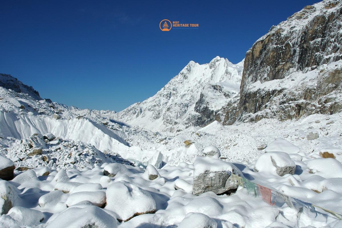
The trek today takes us into a world of rock, ice, and thin air. We follow the trail along the lateral moraine of the massive Kanchenjunga Glacier. The terrain is rugged, crossing several large boulders and sections of loose scree where the path has been carved by glacial movement. As we ascend, the valley opens up into the high-altitude plateau of Lhonak. This settlement consists of a few stone huts and is set on a sandy plain surrounded by spectacular peaks like Wedge Peak (7,021m), Mera Peak (6,364m), and Nepal Peak (7,177m). The views are vast and desolate, truly capturing the "High Route" spirit of the Great Himalayan Trail.
Today is a momentous day as we reach the first major objective of the GHT: the North Base Camp of Kanchenjunga, known as Pangpema. The trail follows the edge of the Kanchenjunga Glacier, traversing steady but challenging moraine slopes. As we reach the base camp, the massive North Face of Mt. Kanchenjunga (8,586m), the third-highest mountain in the world, towers directly above us in a wall of ice and hanging glaciers. After taking time to celebrate, photograph the prayer flags, and absorb the immense silence of the high Himalaya, we retrace our steps back to the relative shelter of Lhonak for the night.
After reaching the northernmost point of this section, we begin our descent back toward civilization. While we are retracing our steps, the perspective is entirely different as we face down-valley toward the massive peaks of the south. The descent is long but allows your body to recover in the increasingly thick air. We pass back through the boulder fields of Khangpachen, where we stop for a midday meal, before continuing through the juniper and larch forests that lead us back to the comfort of Ghunsa. This evening is an opportunity to reorganize gear and prepare for the upcoming technical crossing toward the west.
Today we leave the main Kanchenjunga trail and begin our journey westward. The route starts with a steep climb out of Ghunsa, heading through thick forests of rhododendron and pine. As we gain altitude, the trees give way to alpine shrub and grassy slopes. This is a much quieter trail, rarely visited by standard trekking groups. We are heading toward the base of the Nango La pass. Our High Camp is a secluded spot set in a high basin, offering a rugged, wilderness experience. Tonight we sleep under the stars in a remote setting, preparing our minds and bodies for the pass crossing tomorrow.
Today is one of the most challenging and rewarding days of the early expedition. We begin with a long, steady ascent toward the Nango La Pass. The trail is remote and often obscured by scree and rock, requiring keen navigation. As we reach the summit of the pass at 4,776m, you are treated to a spectacular 360-degree panorama of the Kanchenjunga massif to the east and the mountains of the Makalu region to the west. The descent is steep and long, dropping through alpine meadows into ancient forests of moss-covered rhododendron. We set up camp near the roaring Yangma Khola, surrounded by towering cliffs and the wild beauty of one of Nepal's most isolated valleys.
Today, we traverse toward the remote Yangma valley. The trail involves navigating steep, rugged terrain through a high mountain wilderness that sees very few trekkers. We climb through rocky outcrops and alpine pastures, enjoying the profound silence of the Far East. The descent is steep and long, dropping through alpine meadows into ancient forests of moss-covered rhododendron. We eventually emerge at Olangchun Gola, one of the most remote and historic stone villages in Nepal, famous for its 400-year-old monastery and its history as a vital trade link between Nepal and Tibet.
Leaving the historic village of Olangchun Gola, we head further into the true wilderness. Today’s trek follows the upper reaches of the Tamur River, entering a valley that feels untouched by time. There are no permanent settlements beyond this point, only seasonal grazing pastures used by yak herders. The trail climbs steadily through dwarf rhododendron and juniper scrub as the treeline disappears. We settle into Valley Camp, a high-altitude wilderness site positioned strategically at the base of the climb toward the Lumbha Sambha massif. This is a remote camp where self-sufficiency is key, and the silence of the high Himalaya is absolute.
Today is one of the most significant and strenuous milestones of the entire GHT. We begin well before dawn to tackle the ascent of the Lumbha Sambha La. The climb is steep and demanding, often involving snow and ice, but the reward at the summit is unparalleled: a panoramic view that includes both Mt. Kanchenjunga to the east and Mt. Makalu to the west. This pass connects the Kanchenjunga region to the Makalu-Barun National Park. The descent on the western side is long and knee-jarring, dropping through rugged scree and alpine meadows into a dense forest. We eventually reach Yak Kharka, an incredibly isolated village of stone and wood houses where the residents speak a unique dialect of Tibetan.
Today is a shorter but vital day of trekking. The trail continues through the high glacial valley, following the upper tributaries of the Tamur River. We move through a stark, high-altitude landscape dominated by rock and ice. This day is intentionally designed to be shorter to allow your body further acclimatization and rest after yesterday’s grueling pass crossing. We will spend the afternoon hydrating, and taking in the panoramic views of the surrounding peaks.a
After the intensity of the pass crossing, today’s journey takes us deep into the wild, untamed forests of the Arun Valley. The trail from Thudam is notoriously difficult and narrow, often clinging to steep hillsides. We descend through ancient, moss-covered forests of rhododendron, bamboo, and pine. This area is so remote that the trail can sometimes be obscured by dense vegetation. We follow a path that eventually meets the banks of the Medok Chheje Khola. Our destination is a Kharka (a seasonal grazing clearing) in the middle of the forest. This is "true" wilderness camping - primitive, quiet, and far from any permanent settlement.
The trail continues its descent into the deep, humid gorge of the Arun Valley. This is one of the deepest valleys in the world, and today’s trek highlights the incredible biodiversity of the region. The path remains rugged and can be slippery, winding through dense sub-tropical forests and across several small tributary streams. As we approach Chyamtang, we re-enter civilization. This village is inhabited by the Lhomi people, an ethnic group with a distinct language and culture closely related to Tibet. The village is perched on a steep hillside, surrounded by terraced fields of barley and buckwheat, offering a warm contrast to the high-altitude wilderness of the previous days.
Today is a mandatory rest and recovery day in the culturally rich village of Chyamtang. Situated high above the Arun River, this village is home to the Lhomi people and serves as the final bastion of "civilization" before you strike out into the truly wild, trackless sections of the GHT High Route heading west. Enjoy the unique stone-built houses and the hospitality of the local community. You won't see a village of this size again until you reach the Everest region.
This stage of the journey takes you deeper into the remote Arun Valley as you transition from the larger settlement of Chyamtang toward the culturally distinct village of Hongon. The trail winds through dense rhododendron and bamboo forests, crossing several small tributaries and offering glimpses of the rugged terrain that lies ahead. As you approach Hongon, you'll notice the unique architecture and the traditional lifestyle of the local Shingsaba community, providing a final touch of village hospitality before you head into the more isolated "High Camp" sections of the Great Himalaya Trail.
Leaving the last permanent settlements behind, the trail begins a sustained and steep ascent through ancient, moss-covered forests to reach the high summer pastures of Bakim Kharka. This is a demanding day where the humidity of the lower valleys gives way to the cooler, thinner air of the sub-alpine zone. The "Kharka" or grazing meadow offers a primitive but spectacular campsite, surrounded by the silence of the wilderness and the towering ridges that separate the Arun and Barun watersheds.
Today involves a rigorous climb as you push toward the sacred alpine lake of Molun Pokhari, a significant landmark in this remote corridor. The terrain shifts from dense forest to open alpine scrub and rocky ridges, providing expansive views of the surrounding peaks as you gain nearly a thousand meters in elevation. Molun Pokhari sits in a high, windswept basin, and the mirror-like reflections of the mountains in its waters create an atmosphere of intense isolation and spiritual calm.
After the high-altitude chill of the lake, the route plunges into a steep and technical descent toward the Saldim Khola river valley. This section is notoriously difficult to navigate, often requiring you to push through thick brush and find routes over unstable, mossy terrain where the trail is barely visible. The descent is grueling on the knees, but reaching the riverbank provides a warmer, sheltered environment to recover before the next major ascent toward Makalu.
Continuing along the wild Saldim Khola, you will follow a path that feels more like an animal track than a trekking trail, often involving short scrambles and river crossings. The day is characterized by "up and down" trekking through pristine wilderness where you are unlikely to encounter any other travelers. Your destination is a traditional "Cave Shelter" used by local herders, providing a rugged and atmospheric campsite deep in the heart of the uninhabited mountains.
You begin a long, steady climb out of the river valley, ascending through thinning forests and into the alpine zone to reach Kalo Pokhari (Black Lake). As you gain altitude, the vegetation disappears, replaced by a stark landscape of rock and ice, with the air becoming significantly thinner. The lake itself is deep and dark, often partially frozen, and serves as a vital acclimatization point as you prepare to cross the high ridges leading toward the Makalu Base Camp trail.
This is a high-altitude traverse across a series of ridges and passes that offer spectacular views of the Makalu and Kanchenjunga massifs on a clear day. The walking is slow and methodical due to the elevation, and the terrain consists of loose scree and rocky outcrops that require careful foot placement. You will finish the day at a high Kharka or Cave Camp, a basic and exposed site that serves as the final gateway before dropping down to meet the main Barun Valley trail.
Today you finally intersect with the more established Makalu Base Camp trekking route, descending from the wild ridges into the spectacular Barun Valley. The trail levels out as it follows the glacial river upstream, flanked by vertical granite cliffs and massive waterfalls that freeze into ice pillars in the winter. Reaching Langmale Kharka feels like a return to relative comfort, as this established campsite offers incredible views of Peak 6 and Peak 7, signaling your arrival at the doorstep of the giants.
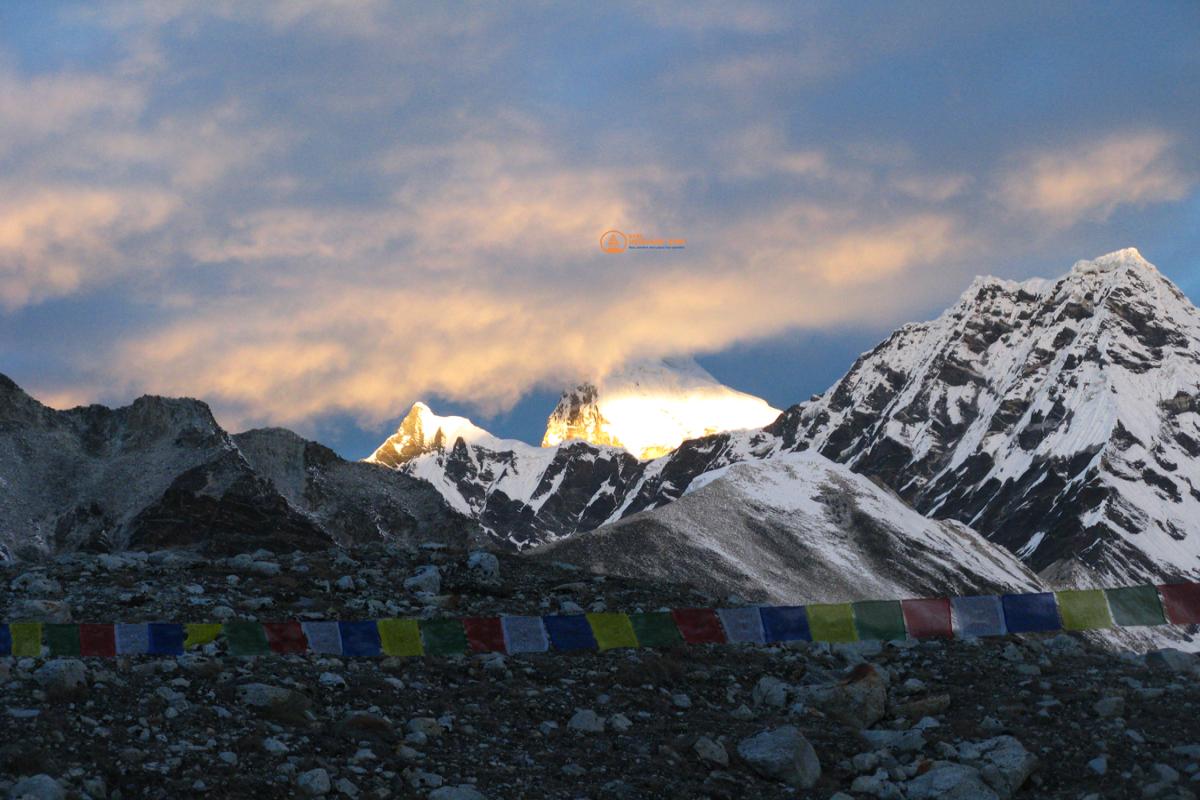
The trek follows the lateral moraine of the Barun Glacier, with the massive south face of Mt. Makalu looming larger with every step until it dominates the entire northern horizon. The landscape is a monochrome world of grey rock, white ice, and deep blue sky, with the high altitude making every uphill section a test of endurance. Upon arriving at Makalu Base Camp, you are surrounded by an amphitheater of 8,000-meter peaks, standing at the base of the fifth-highest mountain in the world in one of the most raw and powerful locations in the Himalayas.
Leaving the base camp, you head west onto the shifting ice and terminal moraine of the Barun Glacier, navigating a maze of boulders and glacial ponds. There is no permanent path here; you follow cairns across the rugged debris, gradually gaining elevation as the terrain becomes increasingly hostile and cold. Sherpani Col Base Camp is a desolate, high-altitude outpost where you will organize your ropes and climbing gear, preparing for the extreme technical challenges of the high passes that begin tomorrow.
This is one of the most demanding and technical days of the entire Great Himalaya Trail, requiring an alpine start long before dawn to navigate the steep snow and ice slopes leading to the summit of the Sherpani Col. Utilizing fixed ropes and crampons, you will ascend the frozen face to reach the narrow ridge of the Col, which offers a staggering panoramic view of the Makalu and Everest massifs. The day continues with a technical descent and a grueling traverse across the West Barun Glacier to reach the Baruntse High Camp, a frozen outpost where the air is thin and the environment is one of pure glacial wilderness.
Today you tackle the highest point of the "Three Cols" by ascending the daunting West Col, a technical climb involving vertical sections of snow and ice that require careful rope management. From the crest of the col, the views of the surrounding 8,000-meter giants are unparalleled, but the focus quickly shifts to the descent, which involves several technical rappels down a sheer rock and ice wall. Once safely off the face, you trek onto the vast, high-altitude plateau of the Honku Basin, a desolate and majestic landscape of frozen lakes and moraine where you will set up camp deep in the wilderness.
The final technical hurdle of this section is the notorious Amphu Labsta Pass, which you approach by crossing the upper Honku Basin and its ice-choked lakes. The ascent is a labyrinth of crevasses and ice seracs, leading to a razor-sharp ridge that provides a dizzying view down into the Imja Valley of the Everest region. The descent is famously steep and dangerous, requiring multiple technical rappels down a vertical rock chimney and icy slopes to reach the safer ground of the lower glacier, where you finally establish camp at the southern base of the pass.
Leaving the high-altitude ice behind, you follow the lateral moraine of the Imja Glacier down into the upper Khumbu valley, passing the massive and growing glacial lake of Imja Tsho. The trail gradually becomes more defined as you descend, and the presence of oxygen becomes more noticeable, easing the physical strain of the previous days. Reaching the settlement of Chhukung marks a return to the world of tea houses, where a warm meal and a bed offer a well-deserved celebration after completing the most technical traverse of the trek.
Today is a high-altitude traverse that keeps you away from the busy lower trails, contouring around the base of Ama Dablam and Taboche with sweeping views of the Pheriche valley. The route is scenic and relatively steady, crossing a small stream and climbing a ridge before opening up into the dramatic hidden valley that leads toward the Cho La Pass. You will end the day in the small hamlet of Dzongla, nestled directly beneath the imposing north face of Cholatse, providing a perfect staging ground for the next pass.
The day begins with a steep scramble over rocky slabs to reach the glacier at the foot of the Cho La Pass, where you will navigate across the ice to reach the prayer-flag-strewn summit. After taking in the views of the Cholatse and Lobuche peaks, you face a steep and rocky descent into the valley before tackling the crossing of the massive Ngozumpa Glacier. The day concludes with a final short climb over the lateral moraine to reach the vibrant turquoise waters of the Gokyo Lakes and the lakeside village of Gokyo.
You leave the Gokyo valley by climbing a steep, well-trodden trail to the top of the Renjo La Pass, which offers what is arguably the most famous view in the Everest region, encompassing Everest, Lhotse, and Makalu above the blue lakes. The descent on the western side is steep and follows a stone staircase into the remote and quiet Bhote Koshi Valley, a traditional trade route from Tibet. The day ends at the small settlement of Lumde, where the atmosphere is significantly more peaceful and traditional than the busier central Khumbu trails.
Today is a gentle and culturally rich descent through the Bhote Koshi Valley, passing through ancient villages and herding settlements that have remained largely unchanged for generations. The trail follows the river downstream, passing Mani walls and chortens that mark the path toward Thame, the historic home of many famous Sherpa climbers. Thame is a significant cultural hub with a prominent monastery perched on the cliffs above the village, and the lower altitude provides a welcome opportunity for recovery and warmth.
You depart the Khumbu region by heading west into the wild Thame Teng valley, ascending steadily away from the villages and back into the high alpine wilderness. The trail is rugged and less traveled, winding through high pastures and rocky terrain as you approach the base of the Tashi Labsta Pass. Your destination is the stunning glacial lake of Parchemuche Tsho, where you will set up a high camp (often called Higher Camp or Dharamsala) in a cold, silent basin surrounded by looming granite peaks.
Today is a grueling and steep ascent onto the glacier as you move toward the crest of the Tashi Labsta Pass. You will navigate through a chaotic landscape of shifting moraine and ice, gaining significant elevation in a very short distance, which makes the thin air feel especially heavy. You will spend the night at the "Top of Pass" Cave Camp, a rugged and exposed rock shelter nestled just below the final pass, providing a stark and dramatic environment for your final night before entering the Rolwaling Valley.
Today involves crossing the formidable Tashi Labsta, a pass notorious for its technical difficulty and objective danger from rockfall. You will ascend steep snow and ice slopes to reach the narrow col, where you are greeted by staggering views of the Rolwaling and Khumbu peaks before beginning a technical descent that often requires fixed ropes. Once off the pass, the route drops onto the vast, debris-covered Trakarding Glacier, a challenging environment of shifting rocks and ice where you will establish a rugged camp amidst the glacial silence.
Leaving the upper glacier, you navigate the complex terminal moraine of the Trakarding to reach the edge of Tsho Rolpa, one of Nepal's largest and most beautiful glacial Lakes. The trail contours along the treacherous northern banks of the Lake, where the path is often etched into steep cliffs, before descending into the sandy flats of the upper Rolwaling valley. You will arrive at Kabug, a serene Riverside campsite that offers a welcome respite from the high-altitude ice and stone of the previous days.
The trek continues down the expansive Rolwaling Valley, passing through the summer settlement of Na Gaon where potato fields are carved out of the rocky earth. As you descend, the valley narrows and the landscape becomes greener, with the thundering Rolwaling Chu River guiding you toward the largest village in the region, Beding. Perched beneath the immense spire of Gauri Sankar, Beding is a traditional Sherpa village with a historic monastery, offering a significant increase in oxygen and the comforts of village life.
Today is a beautiful descent into the lower Rolwaling, where the high-altitude scrub gives way to lush forests of rhododendron, pine, and oak. The trail drops steeply in places, crossing several suspension bridges over deep gorges and passing spectacular waterfalls that cascade down the granite walls. You will feel the air grow warmer and more humid as you reach the forest clearing of Dokhang, a peaceful spot nestled deep within the temperate rainforest.
The trail continues its descent toward the confluence of the Rolwaling Chu and the Tama Koshi, winding through terraced fields and small hillside hamlets. You will encounter more local life as you move through Brahmin and Chhetri communities, eventually climbing a final ridge to reach the village of Simigaon. Famous for its hilltop monastery and commanding views of the surrounding valleys, Simigaon marks your final night in the Rolwaling region before moving westward into the middle hills.
You drop steeply from Simigaon to the banks of the Tama Koshi River before beginning a long, humid climb up the opposite side of the valley. This is a day of "Nepali flat" - constant undulations through sub-tropical forests and vibrant agricultural terraces where locals tend to corn and millet. You will arrive at the ridge-top village of Orangdanda, which offers sweeping views of the rolling green hills and the distant snow-capped peaks of the Gauri Sankar range.
The route traverses through the heart of the middle hills, crossing several ridges and small streams as you move through a tapestry of remote villages. The trail is often a series of stone steps and dirt paths used by locals, offering an authentic look at the rural life of Nepal far from the main tourist circuits. You will descend into the quiet valley of Loting, a lush area surrounded by fertile fields and forests, providing a tranquil environment for your evening rest.
Today involves a steady and scenic climb through rhododendron and oak forests toward the famous Bigu Gompa. This historic nunnery is home to a large community of Buddhist nuns and is renowned for its spiritual atmosphere and beautiful courtyard. The location is spectacular, perched high on a hillside with views that stretch across the deep valleys you have traversed over the last few days, offering a profound sense of peace and cultural immersion.
Leaving the monastery, the trail climbs steeply toward the Tinsang La pass, moving back into the cooler temperate zone where the trees are draped in moss and lichen. You will pass through high-altitude grazing lands and forests before reaching the campsite at Sano Jyandan, located near the pass. This elevated position provides a front-row seat to the sunset over the Jugal and Rolwaling Himal, making it one of the most scenic ridge camps of the mid-section.
This is a massive and knee-jarring descent that takes you from the high ridges all the way down to the Bhote Koshi River valley. The trail drops through various climatic zones, passing through terraced villages until you reach the Arniko Highway, the main road connecting Nepal and Tibet. You will cross the famous suspension bridge to reach The Last Resort, a lush Riverside oasis that offers the luxury of a proper bed, hot showers, and a garden atmosphere after weeks in the wilderness.
Today is a scheduled rest day to allow your body to recover from the grueling Tashi Labsta crossing and the long descents of the previous days. You can take advantage of the resort's facilities, enjoy a massage, or simply relax in the tropical greenery by the River. It is also an essential logistical day to dry out gear, restock supplies, and prepare for the upcoming Tilman Pass crossing into the Langtang region.
You leave the comfort of the resort and cross back over the River to begin a long and steep ascent into the Jugal Himal region. The trail climbs out of the hot River valley, winding through dense forests and small hillside hamlets where the lifestyle is primitive and traditional. As you reach the village of Bagam, the air becomes cooler and you are rewarded with views of the rolling green hills and the distant snow peaks you are heading toward.
The climb continues as you push higher into the uninhabited wilderness of the Jugal Himal, moving through ancient forests that eventually give way to alpine meadows. The trail is remote and often obscured by vegetation, requiring a steady pace as you gain over a thousand meters in elevation. Chogormogor Kharka is a high-altitude grazing meadow used by seasonal herders, providing a quiet and isolated campsite beneath the towering ridges.
Today involves a long and steep descent from the high ridges back down into the River valley to reach the remote village of Tembathang. You will drop through multiple vegetation zones, moving from alpine scrub back into thick temperate forests. Tembathang is a secluded village inhabited by the local Sherpa and Tamang people, offering a fascinating look at life in one of the most isolated corners of the central hills.
Leaving the village, you begin another major ascent as you head toward the sacred Lakes of Panch Pokhari. The trail climbs steadily through pristine forests and across small mountain streams, slowly leaving the inhabited areas behind once again. Nemachukpa Kharka is a high pasture that offers spectacular views of the surrounding peaks, serving as a vital staging point for the higher altitudes to come.
A final climb through rocky terrain and alpine meadows leads you to the sacred site of Panch Pokhari (Five Lakes). These turquoise Lakes are a major pilgrimage site for Hindus and Buddhists, set in a dramatic high-altitude bowl beneath the peaks of the Jugal Himal. The area is filled with small shrines and prayer flags, and the view from the nearby ridge at sunrise is one of the most breathtaking in the central Himalayas.
Today you move deeper into the wild and untracked terrain beyond the main pilgrimage site, heading toward the three Lakes of Tin Pokhari. The walking is challenging as you navigate rocky ridges and scree slopes where the trail is often non-existent. This high-altitude wilderness is incredibly quiet and raw, providing a true sense of the "off-the-beaten-path" spirit of the Great Himalaya Trail as you prepare for the Tilman Pass.
The approach to Tilman Pass begins in earnest as you climb into a world of rock and ice. You will follow the edge of the glacier, navigating through boulders and steep slopes to reach the High Camp on the southern side of the pass. This is a cold and exposed campsite, but it offers magnificent views of the rugged peaks that define the border between the Jugal and Langtang regions.
Today you cross the historic Tilman Pass, named after the famous explorer Bill Tilman. The ascent involves navigating across the snow-covered glacier and through a narrow col that can be quite technical depending on the snow conditions. Once at the top, the views extend deep into the Langtang Valley and toward the peaks of Tibet. The descent on the northern side is steep and often involves scrambling over loose rock and scree to reach the High Camp on the Langtang side.
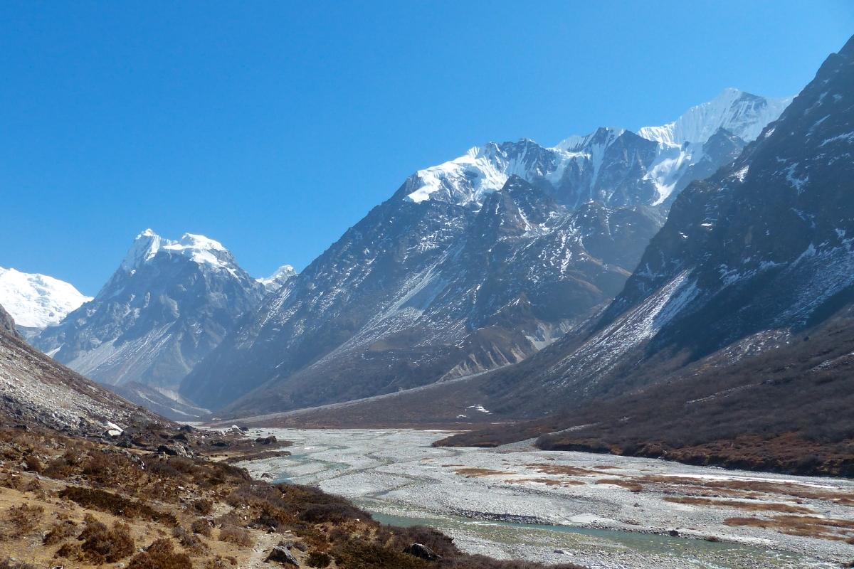
Leaving the high pass behind, you descend into the upper reaches of the Langtang Valley, following the Langshisa Glacier. The trail is rocky and demanding as you navigate the moraine, but eventually, you reach the wide, alpine pastures of Langshisa Kharka. This beautiful valley floor is surrounded by stunning peaks like Kanshurum and Langshisa Ri, marking your successful entry into the Langtang National Park and the halfway point of your 120-day journey.
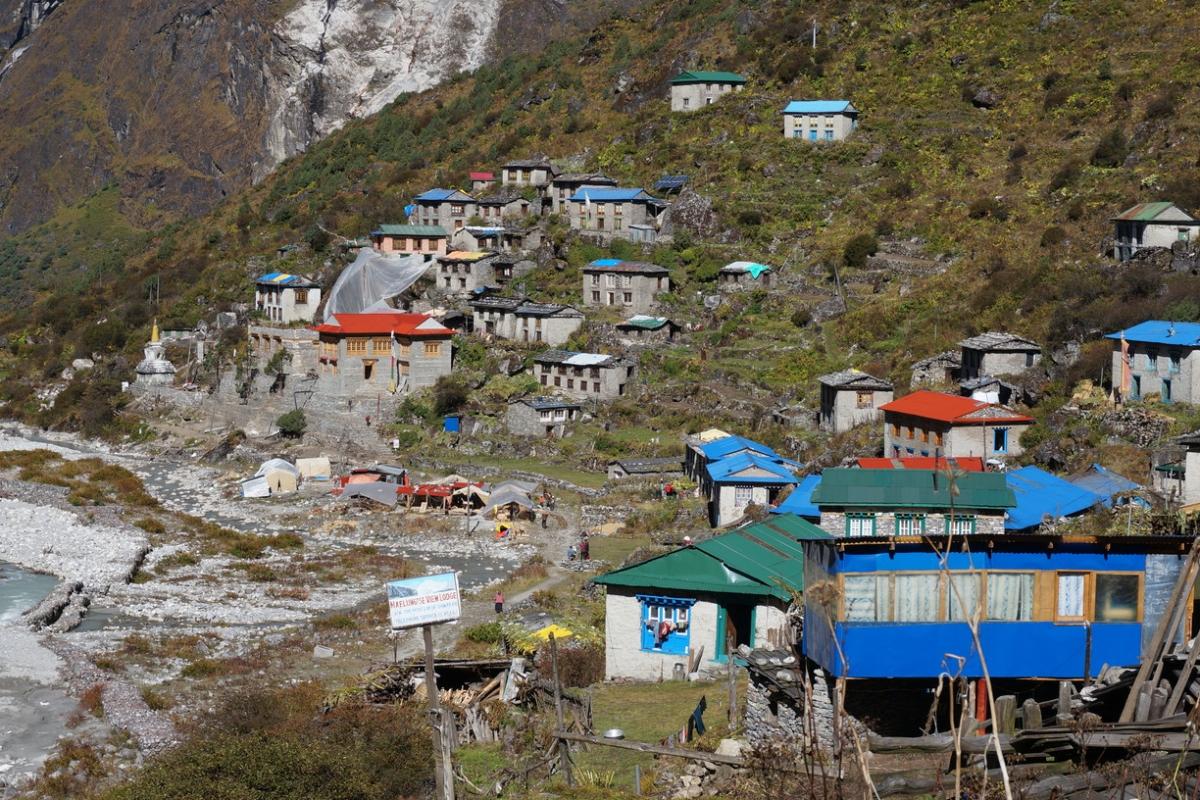
You descend from the wild upper reaches of the Langtang valley, following the glacial River through wide, U-shaped valleys carved by ice. The trail passes through Kyanjin Gompa, where you see the famous yak cheese factory and monastery, before continuing down into the heart of the Langtang National Park. The landscape transitions from high alpine tundra to lush forests of rhododendron and larch as you arrive in Langtang village, which has been remarkably rebuilt following the 2015 earthquake, showcasing the resilience of the local Tamang and Tibetan-influenced communities.
Today is a long, sustained descent through the deep, forested gorge of the Langtang Khola, dropping significantly in altitude. The trail winds through dense woods where you may spot red pandas or langur monkeys among the moss-draped trees. As you reach the confluence of the Langtang and Bhote Koshi Rivers, the temperature rises and the vegetation becomes tropical. You eventually arrive at the bustling trailhead town of Syabru Besi, marking your transition from the Langtang region into the "Tamang Heritage Trail" and the Ganesh Himal foothills.
Leaving the River valley, you climb a series of zig-zags to a high ridge that reveals stunning views of the Ganesh Himal and the peaks of Tibet. The trail passes through the viewpoint of Bahun Danda before descending into the beautiful village of Gatlang, famous for its traditional stone houses with intricately carved wooden windows. This is a day of cultural immersion, as you explore the unique "black village" (so named for its dark stone roofs) and visit the sacred Parvati Kunda Lake located nearby.
The trek follows a long, winding dirt track and forest paths, climbing steadily through forests of pine and rhododendron toward the upper reaches of the Mailung Khola. You pass through several smaller settlements and herding camps, with the massive wall of the Ganesh Himal range growing ever closer. Somdang is a high-altitude settlement located near an old zinc mine, offering a rugged, frontier-like atmosphere and serving as the staging point for crossing the Pangsang Pass tomorrow.
Today offers one of the most spectacular ridge-walks in the Ganesh Himal region as you ascend to the Pangsang La. From the pass, you are treated to a massive 270-degree panorama including Manaslu, the Annapurnas, and the Ganesh Himal peaks. After enjoying the views, you begin a long descent through meadows and then thick forest, finally reaching the large and vibrant village of Tipling, inhabited primarily by the Tamang people and known for its traditional dances and hospitality.
The trail drops steeply to cross the Adha Khola on a suspension bridge before climbing back up to the village of Shertung. You continue along a scenic hillside trail that overlooks the deep Lapa valley, passing through terraced fields of barley and corn. The day is characterized by constant cultural interaction as you pass through these remote, self-sufficient villages, eventually arriving at the Lapa Khola or the village itself, which sits in the heart of the Rubiyala valley.
You begin a sustained climb away from the River, ascending through dense forests of oak and rhododendron into the higher grazing lands of the Ganesh Himal foothills. The trail is less traveled and provides a sense of true solitude as you move between the agricultural middle hills and the high alpine pastures. Nauban Kharka is a high meadow used by herders during the summer, offering a peaceful campsite with wide views of the rolling green ridges and the snow peaks to the north.
This is a significant day of descent as you drop from the high pastures down into the deep gorge of the Budhi Gandaki River. You will transition through various ecological zones, feeling the air become warmer and more humid as you approach the main Manaslu Circuit trail. The descent is steep and finishes at Machhakhola, a hub for trekkers and locals alike, marking the official point where you join the popular route around Mt. Manaslu.
Following the Budhi Gandaki River upstream, the trail narrows into a dramatic gorge with towering cliffs on either side. You will cross several suspension bridges and walk along stone paths carved into the rock face, passing the hot springs at Tatopani. The day ends at the neat, flagstoned village of Jagat, which serves as a checkpoint for the Manaslu Restricted Area and features traditional stone houses that reflect the Tibetan influence of the upper valley.
The climb continues as the valley opens up, revealing spectacular views of Shringi Himal. You pass through various Buddhist villages where Mani walls and chortens become more frequent, indicating your entry into the culturally Tibetan "Tsum" and "Nupri" regions. After crossing the Budhi Gandaki several times on suspension bridges and passing through the bamboo forests of Philim, you reach the small settlement of Deng, a quiet village perched high above the River.
Today involves a steady ascent through the forest, crossing the River and climbing steep stone stairs as the terrain becomes more alpine. You will pass through the village of Bihi and begin to see the first glimpses of Manaslu and its surrounding glaciers. The trail is increasingly decorated with elaborate Mani walls and prayer flags, leading you to the village of Namrung, which is famous for its excellent viewpoints and traditional stone architecture.
As you move into the upper Nupri region, the landscape transforms into a vast alpine valley surrounded by glaciers and peaks. You pass through the village of Lho, dominated by a large monastery and a stunning view of Manaslu’s double summit. The trail then continues through the forest of Shyala before emerging into the wide plateau of Sama (Sama Gaon), the largest village in the region and a major hub for mountaineering expeditions heading to the world's eighth-highest mountain.
This is a shorter day in terms of distance but crucial for acclimatization as you approach the 4,000-meter mark. The trail follows the Budhi Gandaki River north, passing the entrance to the Manaslu Base Camp trail and moving through juniper and birch forests that slowly give way to alpine scrub. Samdo is a remote village of Tibetan refugees, located only a day's walk from the Tibetan border, and its high-altitude setting provides a stark, beautiful backdrop of snow-capped Mountains.
Leaving Samdo, you descend slightly to cross a bridge before beginning a steady climb toward the Larkya Phedi (Dharamsala). The landscape is now entirely alpine, consisting of rock, ice, and sparse vegetation, with the massive Larkya Glacier dominating the view. This is a high-altitude outpost where you will spend the night in basic conditions, focusing on rest and hydration in preparation for the crossing of the Larkya La pass tomorrow.
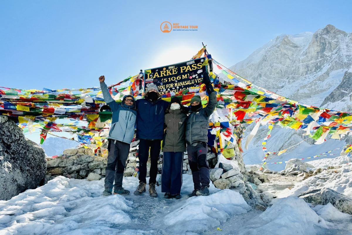
Today is the highlight of the Manaslu Circuit, involving a long, steady ascent across the moraine and snow slopes to reach the prayer-flag-strewn summit of the Larkya La. The pass offers an incredible panorama of Himlung Himal, Cheo Himal, and the massive Annapurna II. The descent is steep and technical, dropping over 1,400 meters down a rocky trail and lateral moraine into the beautiful, glacier-ringed basin of Bimtang, providing a sense of immense accomplishment and relief.
The trail descends from the high glacial basin into a lush forest of rhododendron, pine, and oak, following the Dudh Khola River. You will pass through several summer settlements and cross various suspension bridges as the valley narrows. The day ends at Dharapani, a busy hub where the Manaslu trail joins the famous Annapurna Circuit, marking your entry into the Marshyangdi River valley and a return to more established trekking infrastructure.
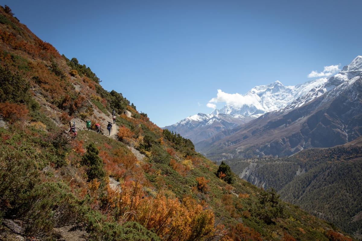
You begin your journey along the Annapurna Circuit, climbing steadily through the Marshyangdi valley. The trail follows the River upstream, passing through the village of Bagarchhap and under the impressive waterfalls of Danaque. As you gain altitude, the forest changes to pine and fir, and the massive peaks of Annapurna II and Lamjung Himal begin to dominate the horizon. Chame is the administrative headquarters of the Manang district and offers comforts like hot springs and better amenities.
Today's trek takes you through a dramatic landscape where the River has carved a deep gorge through solid rock. You will pass the famous "Paungda Danda" rock face, a massive curved slab of stone that rises 1,500 meters above the River. The trail eventually opens up into the wide, arid valley of Upper Manang, leading you to the village of Pisang. You can choose to stay in Lower Pisang or climb to Upper Pisang for even better views of the Annapurna range.
You have a choice between the lower, easier trail or the higher, more scenic route via Ghyaru and Ngawal. The high route offers some of the most spectacular views in the Himalayas, looking directly across the valley at the Annapurna summits and Gangapurna. Both trails eventually converge at the historic village of Manang, a large settlement with a distinct Tibetan character, ancient monasteries, and a wide array of facilities for trekkers preparing for the Thorong La pass.
Leaving the bustling village of Manang, the trail climbs steadily out of the valley, moving into the high-altitude pastures where yaks are grazed during the summer. You cross several small streams and navigate around rocky ridges, with the air becoming noticeably thinner. Yak Kharka is a small collection of lodges nestled in a windswept valley, serving as a vital acclimatization stop that bridges the gap between the lower valley and the high-altitude base camps of the Thorong La.
The trail continues its gradual ascent toward the foot of the Thorong La pass, winding through high alpine terrain where the landscape becomes increasingly stark and rocky. You will cross a suspension bridge over the Kone Khola before navigating a stretch of trail prone to landslides, requiring a steady pace and focus. Thorong Phedi is a busy base camp nestled in a narrow valley beneath towering rock walls, serving as the final resting point for hundreds of trekkers before the grueling climb to the pass; here, the thin air and cold temperatures remind you of the massive altitude to be gained tomorrow.
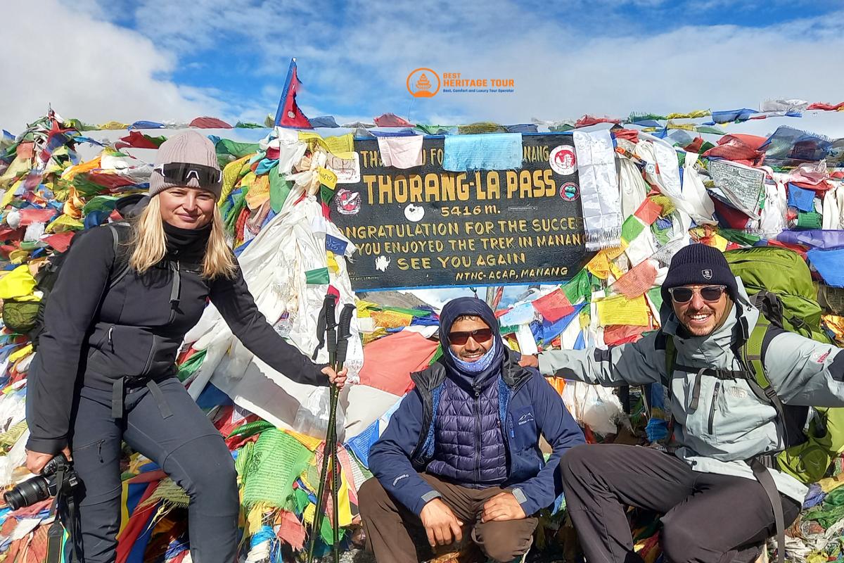
Beginning long before dawn, you tackle the long and steady climb to the summit of the Thorung La, the highest point on the Annapurna Circuit. The ascent is a test of endurance through snow and thin air, but the reward at the prayer-flag-strewn crest is a breathtaking panorama of the Dhaulagiri and Annapurna massifs. The descent is steep and long, dropping nearly 1,600 meters into the arid, desert-like landscape of Mustang to reach the sacred pilgrimage site of Muktinath. This revered temple complex, holy to both Hindus and Buddhists, marks your transition into the ancient Kingdom of Lo and the Kali Gandaki valley.
Today is a scenic descent through the rain-shadow landscape of Mustang, passing through the ancient, wind-swept villages of Jharkot and Khingar with their traditional Tibetan architecture. The trail offers vast views of the Kali Gandaki Riverbed and the towering Nilgiri peaks as you drop into the "Grand Canyon" of Nepal. You will arrive at Kagbeni, a fascinating medieval village that serves as the gateway to Upper Mustang. With its narrow alleys, ancient mud-brick houses, and red monasteries, Kagbeni provides a rich cultural finale to your journey through the Annapurna region.
This rest day is essential for recharging and resupplying before you head into the extreme isolation of Upper Dolpo. You can spend the day exploring the 15th-century Kag Chode Thupten Samphel Ling Monastery or wandering through the village’s labyrinthine tunnels designed to protect residents from the fierce afternoon winds. Your team will finalize permits and organize the heavy supplies needed for the next 20 days of wilderness trekking, where tea houses will be replaced by remote camps and high-altitude passes.
You leave the Kali Gandaki valley and climb westward into the rugged, arid ridges that separate Mustang from Dolpo. The trail is steep and demanding, crossing the Bhima Lojun La as it traverses a landscape of crumbling cliffs and deep gorges. This is one of the most remote sections of the GHT, and the village of Santa is a tiny, isolated outpost of stone houses tucked into a dry valley. Reaching Santa marks the beginning of your journey into the true "trans-Himalayan" wilderness, where the terrain is as beautiful as it is unforgiving.
The trail climbs steadily out of Santa, following a high-altitude traverse across vast, empty slopes that offer immense views of the Dhaulagiri range. The path is often narrow and exposed, winding through a world of grey rock and golden grass where the wind is a constant companion. You will cross several minor ridges before descending toward the Ghalden Ghuldun Khola, a remote River valley where you will set up camp. This area is completely uninhabited, providing a deep sense of solitude as you move further away from civilization.
Today is a strenuous crossing of the Jungben La, a high and windswept pass that serves as a major gateway into Upper Dolpo. The ascent is long and demanding, moving through a landscape of scree and alpine desert where the oxygen is scarce but the vistas of the Tibetan plateau are limitless. From the summit, you descend into a high-altitude wilderness toward Nulungsunda Kharka, a primitive grazing meadow. This is high-altitude trekking at its most raw, where the weather can change in an instant and the silence of the Mountains is absolute.
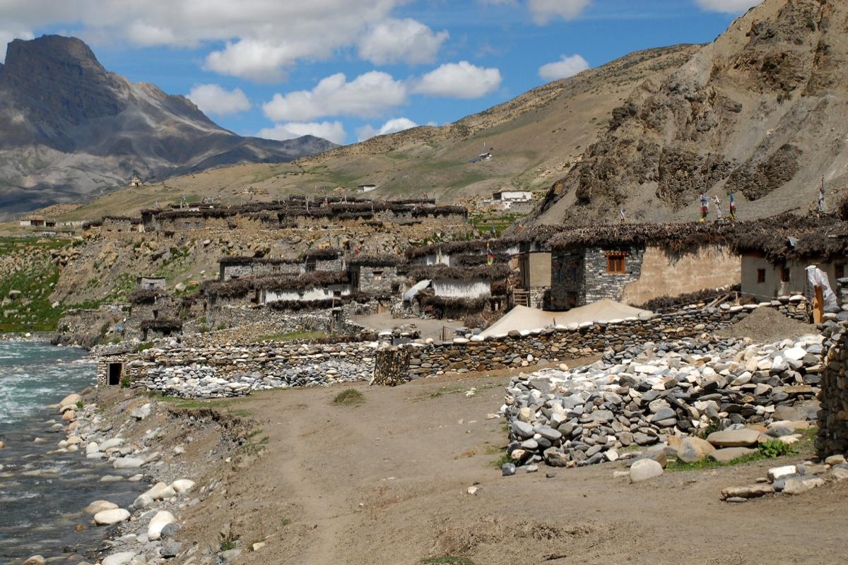
You descend from the high pastures into the wide, arid valley of the Barbung Khola, eventually reaching the ancient village of Chharka Bhot. This is one of the highest and most remote permanent settlements in the world, where the local people still follow a traditional Tibetan lifestyle centered around yak herding and Bon religion. The village is a fortress-like cluster of mud-brick houses and Mani walls, standing as a testament to human resilience in the extreme cold and altitude of the Dolpo region.
Leaving Chharka Bhot, the trail follows the River upstream through a stark, beautiful landscape of eroded hills and vast valley floors. The trekking is relatively steady compared to previous days, but the altitude remains high, requiring a slow and rhythmic pace. You pass through a wilderness where blue sheep and Himalayan griffons are common sights, eventually reaching the campsite at Chap Chu. This is a vital resting point before you begin the series of high passes that lead toward the heart of Dolpo.
The climb to the Chan La is a long and challenging ascent through a monochrome world of rock and occasional snow patches. Reaching the top of the pass rewards you with a panoramic view of the rugged, folded Mountains of Dolpo, looking back toward Mustang and forward into the Dho Tarap region. The descent leads you into a quiet valley toward the small settlement of Maran, where the architecture and culture reflect the deep Tibetan roots of the local Khampa people.
Today you traverse the rolling ridges and valleys that lead toward the high-altitude hub of Dho Tarap. The trail is scenic, moving through vast pastures where you might encounter nomadic herders and their yak caravans. The landscape is dotted with white-washed chortens and prayer flags, creating a spiritual atmosphere in this isolated mountain desert. You will camp at a site traditionally known as Dharamsala, a basic stopping point that positions you perfectly for the crossing of the Numa La tomorrow.
Today involves crossing the first of the two great passes of Lower Dolpo, the Numa La. The trail climbs steeply over scree and rocky ridges to reach the summit, which offers incredible views of the Dhaulagiri massif and the Kanjirowa peaks. The descent on the other side is equally steep, leading you into a beautiful, hidden valley where the Danigar campsite sits beside a high-altitude stream. This is a physically demanding day that showcases the dramatic, high-contrast beauty of the Dolpo landscape.
You begin the day with a climb to the Bagala La, the second major pass in this section, offering a fresh perspective of the vast, arid valleys of Dolpo. The summit provides a final high-altitude panorama before you begin a long, sustained descent into the greener landscapes that surround Phoksundo Lake. The trail leads through alpine meadows and into forests of blue pine and juniper, reaching the Temche campsite as the air becomes richer and the environment more vibrant.
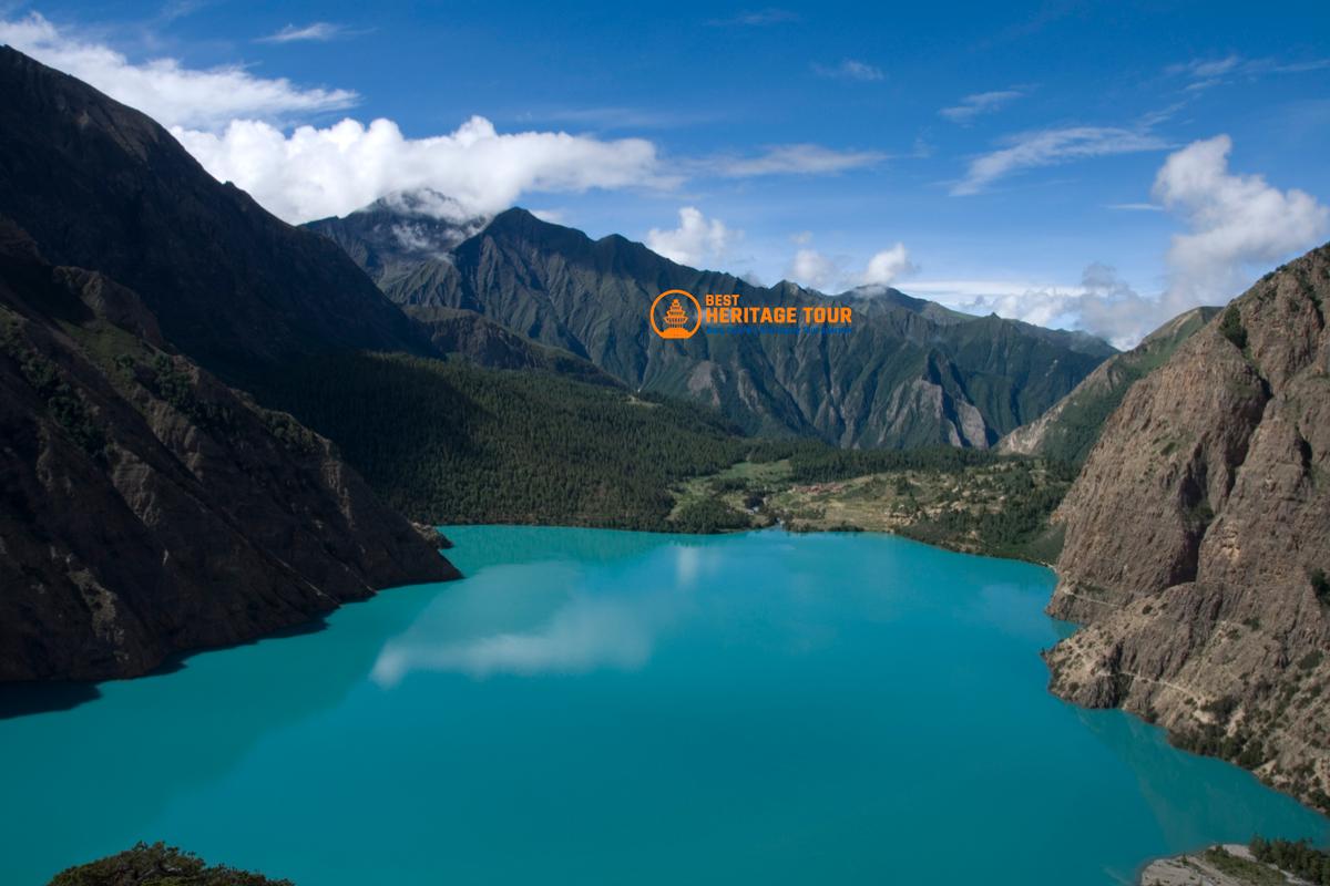
The trail drops through lush forests and passes spectacular waterfalls as you approach the village of Ringmo. You will eventually be greeted by the breathtaking sight of Phoksundo Lake, its deep turquoise waters standing in stark contrast to the surrounding white peaks and brown cliffs. Ringmo is a culturally rich Bon village perched at the edge of the Lake, providing a fascinating insight into an ancient religion that predates Tibetan Buddhism. Resting here by the deepest Lake in Nepal is a major highlight of the entire trek.
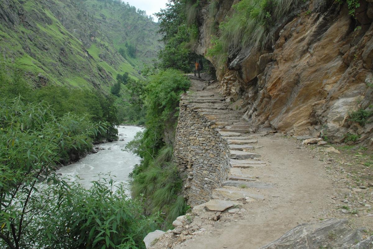
Leaving Ringmo, you follow the famous "devil's trail" - a narrow path carved directly into the vertical cliffs high above the Lake - providing some of the most dramatic and photogenic views of the entire journey. Once you reach the northern end of the Lake, the trail climbs into the rugged valley of the Phoksundo Khola. You will establish a high camp in the upper valley, far above the Lake shore, in preparation for the crossing of the Nagdalo La that leads into the sacred Shey region.
The climb to the Nagdalo La (also known as Kang La) is a steep scramble over loose rock and scree, reaching a height that offers incredible views of the Crystal Mountain and the vast Tibetan plateau. The descent into the Shey valley is steep and scenic, leading you toward the legendary Shey Gompa, an 800-year-old monastery nestled at the base of the sacred Crystal Mountain. This is the spiritual heart of Upper Dolpo, a place made famous by Peter Matthiessen's "The Snow Leopard," where the ancient traditions of Tibetan Buddhism are preserved in absolute isolation.
You leave the sacred Shey region and head west toward the remote village of Bijer, traversing high-altitude ridges and dry, wind-sculpted valleys. The trail is long and requires navigating several minor passes, offering a landscape that feels more like the moon than the earth. Bijer is a traditional village known for its large monastery and its history as a center for Tibetan medicine (Amchi). The isolation here is profound, and the local hospitality provides a warm welcome in one of the most distant corners of the Nepal Himalaya.
Today’s trek involves a steady climb to the Yambur La, which offers wide vistas of the Kanjirowa range and the deep canyons of the Langu valley. After the pass, the trail drops into a wild and rugged area, leading you to the tiny, isolated village of Pho. Perched on a high slope above the River, Pho is one of the most self-sufficient and remote villages in the world, where the people live a life largely unchanged by the outside world, providing a true GHT wilderness experience.
This is a challenging day as you cross the high Nyingma Gyanzen La, the final great pass of the Dolpo region. The ascent is long and demanding, navigating steep slopes and thin air to reach a summit that overlooks the vast, empty territory stretching toward Mugu. The descent leads you into the high pastures of Pung Kharka, a desolate but beautiful grazing area. You are now in a true frontier zone, moving through a landscape where there are no villages, only the raw elements of the high Mountains.
Your 100th day is marked by the crossing of the Yala La, a technical and high-altitude pass that leads you out of Dolpo and toward the Mugu district. The trail involves navigating across rocky ridges and snow fields, requiring endurance and focus as you reach the pass's summit. From here, you descend into the deep and remote valley of the Chyandi Khola, where you will set up a wilderness camp. You have now completed a century of days on the trail, having traversed nearly the entire width of the Nepal Himalaya.
Following the completion of the grueling Yala La, the trail begins a long descent along the banks of the Chyandi Khola, entering a deeply isolated valley system where few travelers ever venture. The terrain transitions from high-altitude rock and ice to alpine scrub and eventually sparse forests as the oxygen levels begin to rise. You will navigate through narrow gorges and over rocky outcrops, following the River downstream until it meets the Takla Khola. This wilderness camp offers a more sheltered environment than the high passes of Dolpo, providing a necessary recovery point as you push westward into the Mugu district.
Today involves one of the final significant high-altitude climbs of the journey as you tackle the Chyargo La. The ascent is steady and demanding, requiring you to navigate scree slopes and occasional snow patches to reach the summit, which offers a sweeping view of the remote Mugu Mountains and the distant Tibetan plateau. The descent on the western side leads you into the high-altitude meadow of Thajuchaur, a peaceful grazing area surrounded by rugged peaks. This stage marks your transition into the central Mugu region, where the landscape begins to soften from the harshness of the trans-Himalaya into more verdant hills.
The trail drops steeply from the high meadows of Thajuchaur, descending through various ecological zones as you head toward the Mugu Karnali River system. You will leave the alpine zone behind and enter dense forests of pine, spruce, and birch, where the air feels noticeably warmer and richer. Shilenchaura Kharka is a beautiful forest clearing near the Riverbank, offering a tranquil campsite where the sound of the thundering Mugu Karnali provides a constant backdrop. After weeks in the high-altitude deserts of Dolpo, the greenery and biodiversity of this valley are a refreshing change for the senses.
You follow the Mugu Karnali River downstream, navigating a path that winds along the valley floor and across steep hillside contours. This section of the trail brings you back into contact with the first signs of human habitation since leaving Pho, as you pass seasonal herding huts and small cultivated patches. The village of Tiyar is a remote outpost where the culture begins to shift from purely Tibetan toward the Khas influence of western Nepal. The walk is relatively easy compared to the high passes, allowing you to enjoy the lush canyon scenery and the powerful flow of one of Nepal’s longest River systems.
The trek continues along the River, passing through a series of small, traditional villages where the architecture is characterized by flat-roofed mud houses. You will see more local activity as villagers tend to their fields of barley and buckwheat, reflecting the agricultural lifestyle of this remote district. The destination for the day is Mangri, a culturally significant village with a large chorten and a mix of Tibetan and Khas residents. This area is much lower in elevation, and the humidity and warmth of the valley signify that you are entering the final phases of your cross-country traverse.
Leaving the Mugu Karnali, the trail begins a steady climb away from the River toward Gamgadhi, the administrative headquarters of Mugu district. After passing through the bustling marketplace of Gamgadhi, you continue a scenic hike through fragrant pine forests to reach the shores of Rara Lake, Nepal's largest Lake. The sight of the deep blue water reflecting the surrounding snow-capped peaks is a magnificent reward for the day's effort. You will establish your camp near the Lake’s edge, experiencing one of the most serene and beautiful natural landmarks in the entire country.
Today is a dedicated rest day at the jewel of the West, Rara Lake. You can spend the day walking the easy 13km trail around the Lake's perimeter, birdwatching, or simply relaxing in the peaceful meadows that surround the water. It is a time to reflect on the incredible journey of the past 100+ days while enjoying the hospitality of the Rara National Park. The elevation is comfortable, the air is clean, and the absence of high-altitude stress makes this one of the most enjoyable recovery days of the entire itinerary.
The journey moves westward as you depart Rara Lake and begin a descent through the hills of the Karnali region. The trail winds through dense forests of oak and rhododendron before opening up into terraced hillsides dotted with small, traditional farming hamlets. You will encounter the local Khas people, whose distinct language and culture define this part of Nepal. The village of Bam is a quiet settlement perched on a ridge, offering expansive views of the rolling green hills that stretch toward the Humla district, your final destination.
Today is a day of ridge-walking and valley crossings, following a trail that undulates through the middle hills of western Nepal. You will climb steadily to reach higher ground, passing through ancient cedar forests and over small streams. The path is often used by local salt caravans and traders, maintaining a historical connection to the trade routes between the hills and the Tibetan border. Jogimara is a small, hilltop settlement that provides a scenic camping spot with views of the distant high peaks of the Humla region appearing on the horizon.
A significant descent brings you down from the ridges into the deep and humid valley of the Humla Karnali River. The landscape becomes more tropical as you drop in altitude, with orange trees and lush vegetation appearing around the villages. This section of the trek highlights the extreme geographical diversity of the GHT, as you move from high alpine passes to warm River valleys in just a few days. You will reach Piplan, a vibrant village located near the Riverbank, where the richer soil supports a variety of crops and a denser population.
Leaving the River valley, you begin a long and sustained climb up toward the ridges of Apsi Lekh. The trail is steep and demanding, winding through forests that slowly change from sub-tropical to temperate as you gain elevation. This climb is necessary to cross the high ground between the River systems and offers commanding views of the deep Karnali gorge below. Apsi Lekh is a high-altitude grazing area where you will camp, enjoying the cooler temperatures and the clear, wide-open vistas of the western Nepal sky.
The trail traverses high along the hillsides, moving through a landscape of rugged cliffs and deep tributary valleys. You will navigate around several ridges, experiencing the "up and down" nature of the western Nepali hills before descending toward the Punkha Khola. This River valley is secluded and wild, offering a primitive campsite by the water. The area is largely uninhabited, providing a sense of frontier wilderness as you approach the final high ridges that separate you from the Simikot valley.
Today involves crossing the Margor Lekh, a high ridge that provides a natural barrier between the Mugu and Humla districts. The ascent is steady through thinning forests until you reach the grassy summit of the pass, where you are rewarded with a panoramic view of the Humla Mountains and the path ahead. The descent leads you into the Yanchu Khola valley, a scenic area with waterfalls and rocky streams. This is the final major ridge crossing before you reach the administrative hub of Simikot.
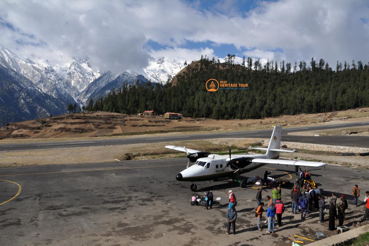
The trail follows the River before climbing a final ridge that overlooks the Simikot plateau. As you approach Simikot, the administrative heart of Humla, you will see the first airstrip in weeks and a bustling town filled with government offices, shops, and trekkers heading toward Mt. Kailash. Reaching Simikot is a major milestone, as it serves as the final gateway for the last leg of your journey toward the Tibetan border at Hilsa. You will stay in a tea house, enjoying a sense of civilization before the final push westward.
You leave Simikot and begin the final trek along the Humla Karnali River, following a trail that is part of the ancient pilgrimage route to Mt. Kailash. The path winds along the side of the deep gorge, passing through fields of barley and mustard and through small villages like Dharapori. The trail is well-trodden but scenic, leading you to the village of Kermi. Near the village, there are natural hot springs where you can soak and relax, a perfect treat for your tired muscles as you approach the end of your 120-day odyssey.
The trail continues to follow the Humla Karnali upstream, entering a more arid and rugged landscape as you gain altitude. You will cross several suspension bridges and pass through the village of Yalbang, which features a beautiful and active monastery with views of the River below. The path is spectacular, carved into the cliffs in some sections, eventually leading you to the village of Muchu. The culture here is strongly Tibetan, and the white-washed houses and chortens reflect the proximity to the border and the high-altitude plateau.
Leaving Muchu, the trail climbs steadily away from the River, passing through the village of Tumkot and moving into a stark, trans-Himalayan landscape. The vegetation becomes sparse, replaced by juniper bushes and rocky slopes as the air becomes thinner and colder. You are now on the final approach to the Nara La pass, and the village of Yari serves as the last permanent settlement before the border. The sense of anticipation is high as you prepare for the final pass of your Great Himalaya Trail journey.
Today marks the emotional and physical conclusion of your trek as you cross the Nara La pass. The climb is steady and offers a final look back at the rugged Mountains of Nepal before the summit reveals the vast, brown plains of the Tibetan plateau stretching out before you. The descent is steep and leads directly to the border town of Hilsa, situated on the banks of the Humla Karnali. Reaching the suspension bridge that marks the border is the triumphant end of your 120-day journey across the entire length of the Nepal Himalaya.
After the immense feat of walking across the country, today you travel back to Simikot by jeep along the newly constructed mountain road. The drive takes several hours, winding back through the gorges and villages you passed on foot, offering a different perspective of the landscape. Reaching Simikot, you will check into a lodge for your final night in the Mountains, perhaps enjoying a celebratory dinner with your team. It is a day of transition, moving from the rhythm of the trail back toward the pace of modern travel.
Your epic journey concludes with a flight from the mountain airstrip of Simikot down to Nepalgunj, followed by a connecting flight back to the capital, Kathmandu. As the plane soars over the peaks and valleys you have spent the last four months traversing, the scale of your achievement becomes truly apparent. Arriving in Kathmandu, the heat, noise, and bustle of the city are a sharp contrast to the silence of the high passes. You have successfully completed one of the most challenging and magnificent long-distance treks on Earth.
What is included?
- All Domestic Flight as per the Itinerary
- All Ground Transportation in a Private/Shared Vehicle as per the Itinerary
- Accommodation in Tea houses/lodges or Camp during the trek on twin-sharing basis
- Meals (Breakfast, Lunch and Dinner) during the trek
- Trekking equipment (tent for 2 people, dining tent, kitchen tent, table with chairs, cooking utensils, and other equipment required during the trek)
- All Necessary Permits & their Cost
- An Experienced government certified English speaking trekking guide plus an assistant guide for group of 12+ trekkers
- Porters for luggage support (with maximum weight of 25 kg)
- All expensed of Guide and Porter such as salary, meal, accommodation, insurance etc
- First-aid support and emergency procedures like helicopter rescue (funded by travel insurance)
- Souvenirs - Best Heritage Tour T-shirt and Purse
- Best Heritage Tour achievement certificate after the competition of trek
- A farewell dinner in Kathmandu
What is not included?
- International Airfare to Nepal
- Visa fee for Nepal
- Accommodation and meals in Kathmandu, before and after the journey
- Additional night accommodation in Kathmandu due to early arrival or late departure, or early return from the trek.
- Personal expenses (shopping, snacks, boiled bottled water, hot (tea / coffee) and cold drinks, hot shower, alcohol, Wi-Fi, telephone call, battery recharge fee, extra porters, etc.
- Personal trekking gear and clothing
- Travel insurance covering emergency high-altitude rescue and evacuation (mandatory)
- Tips for guides and porters (recommended)
- Additional costs resulting from factors beyond our control, such as landslides, weather conditions, itinerary adjustments due to safety concerns, illness, changes in government policies, strikes, etc.
- All government taxes 13%, SSF, and 10% service charges
Route Map
Equipment
Technical Climbing Gear
-
Mountaineering Boots (Stiff, Category D or B3 crampon-compatible)
-
Crampons (12-point, fitted to boots)
-
Ice Axe (Lightweight, for glacier travel)
-
Climbing Harness (Fully adjustable)
-
Climbing Helmet (UIAA certified)
-
Carabiners (2x Screw-gate, 2x Snap-gate)
-
Descender/Belay Device (ATC or Figure-8)
-
Prusik Loops (6mm diameter)
Outerwear & Layers
-
Expedition Down Jacket (Rated to -25°C)
-
Lightweight Down/Synthetic Jacket
-
Hard Shell Jacket & Trousers (Gore-Tex or equivalent)
-
Soft Shell Jacket (Wind-resistant)
-
Mid-weight Fleece Layers
-
Base Layers (3x sets Merino wool or synthetic)
-
Trekking Trousers (2x pairs)
-
Thermal Leggings
Footwear & Handwear
-
Trekking Boots (Waterproof, broken-in)
-
Camp Shoes (Lightweight sandals or down booties)
-
Socks (6x pairs Heavy Wool, 4x pairs Liners)
-
Gaiters (Knee-high, waterproof)
-
Liner Gloves (Thin, synthetic)
-
Mid-weight Gloves (Waterproof/insulated)
-
Heavy Mittens (Down-filled for high passes)
Sleeping & Carrying Gear
-
Sleeping Bag (4-season, rated to -20°C or lower)
-
Sleeping Bag Liner (Silk or Fleece)
-
Main Expedition Duffel (80-100L, waterproof)
-
Daypack (30-40L)
-
Trekking Poles (Collapsible with snow baskets)
Head & Vision
-
Glacier Glasses (Category 4 protection)
-
Ski Goggles (For high-pass wind/snow)
-
Headlamp (With 3 sets of spare batteries)
-
Warm Hat (Wool or fleece)
-
Sun Hat/Cap
-
Neck Gaiter/Buff (2x)
Electronics & Hygiene
-
Solar Charger (Foldable, for remote regions)
-
Power Bank (20,000mAh minimum)
-
Water Purification (UV Filter or Chlorine Dioxide drops)
-
Personal First Aid & Blister Kit
-
Toiletry Kit (Biodegradable soap, quick-dry towel)
- Sunscreen & Lip Balm (SPF 50+)
Trip Info
Best Time for the Great Himalayan Trail
For an expedition of this magnitude, timing isn't just about the view - it’s about survival and accessibility. To complete the full traverse of the Great Himalayan Trail, there is only one viable window that aligns with the opening of the high technical passes.
The Ultimate Window: Spring (March to July)
The full GHT traverse is traditionally undertaken starting in late February or early March. This allows you to move from East to West, timing your arrival at the high technical passes just as the winter snow begins to melt but before the monsoon rains arrive.
March - April (The Eastern Start):
Starting in the Kanchenjunga region during early spring offers crisp air and spectacular rhododendron blooms in the lower valleys. The weather is stable, providing clear views for the initial high-altitude stages.
May - June (The High Passes):
This is the "Golden Window" for the technical crossings. The Sherpani Col, West Col, and Tilman Pass are safest during this period. The deep winter snow has compacted or melted, and the extreme cold of winter has subsided, making the 6,000-meter sections manageable.
June - July (The Western Finish):
As you move into the rain-shadow regions of Upper Dolpo and Humla, you are shielded from much of the monsoon. While the rest of Nepal begins its rainy season, these arid, Tibetan-like plateaus remain relatively dry, allowing you to finish the trek in the Far West under dramatic, moody skies.
Why Autumn (September-November) is a Challenge?
While Autumn is the most popular time for shorter treks (like Everest Base Camp), it is not recommended for a full 120-day continuous traverse. Starting in September would mean hitting the high passes of the West in December or January, when heavy snowfall and extreme sub-zero temperatures make the technical cols impassable and life-threatening.
Tip: We plan our departure specifically to hit the 'sweet spot' of May for the Three Cols. Crossing these technical glaciers any earlier means fighting chest-deep snow; any later, and you risk the afternoon storms of the pre-monsoon.
Permits Required for the Great Himalayan Trail
Because the Great Himalayan Trail (GHT) traverses nearly every protected area in Nepal, the paperwork is as extensive as the trail itself. Navigating these regulations is a massive undertaking, but Best Heritage Tour handles the entire process for you.
To complete this 120-day odyssey, we secure a complex "Permit Portfolio" that includes:
1. Restricted Area Permits (RAP)
Many sections of the GHT lie in sensitive border regions near Tibet. These require special government permits that are only issued to registered trekking agencies. We secure RAPs for:
-
Kanchenjunga & Olangchun Gola: Far East restricted zones.
-
Upper Dolpo: The most expensive and exclusive permit in Nepal.
-
Upper Mustang & Manaslu: Necessary for the transition through the North-Central regions.
-
Humla (Simikot/Hilsa): The gateway to the Far West finish line.
2. National Park & Conservation Area Permits
We register you across the diverse ecological zones of the Himalayas. This includes:
-
Kanchenjunga Conservation Area (KCAP)
-
Makalu Barun National Park
-
Sagarmatha (Everest) National Park
-
Gaurishankar Conservation Area (GCAP)
-
Langtang National Park
-
Manaslu Conservation Area (MCAP)
-
Annapurna Conservation Area (ACAP)
-
Shey Phoksumdo National Park (Nepal's largest)
-
Rara National Park
3. TIMS Card (Trekkers' Information Management Systems)
This is the standard tracking permit required for all trekkers in Nepal to ensure your location is known for safety and search-and-rescue purposes.
4. Peak Climbing Permits (For Technical Cols)
Because sections like the Sherpani Col and West Col exceed 6,000 meters and involve technical mountaineering, we secure the necessary NMA (Nepal Mountaineering Association) permits to ensure your crossing is legal and fully insured.
Important Requirements for GHT Permits:
-
Passport Validity: Your passport must be valid for at least 6 months beyond the trek's end date.
-
Visa: You will need a 150-day multiple-entry Nepal Visa (often extended in Kathmandu) to cover the full duration and any travel buffer days.
-
Photos: We require at least 12-15 passport-sized photos from you to process the various regional permits.
-
Insurance: Proof of comprehensive mountain insurance (covering search, rescue, and evacuation up to 6,500m) is mandatory for us to secure these permits.
Note: Permit fees contribute directly to the conservation of these fragile ecosystems and the heritage of the local tribes. By trekking legally with us, you are directly funding the protection of the land you walk upon.
Accommodation & Meals
On a 120-day journey across the Great Himalayan Trail, your "home" and your "fuel" are the two most critical components for success. At Best Heritage Tour, we utilize a hybrid approach that balances local immersion with expedition-grade wilderness support.
Accommodation: From Heritage Homes to High-Altitude Base Camps
Because the GHT spans everything from developed trekking hubs to completely uninhabited wilderness, your sleeping arrangements will vary by phase:
-
Authentic Teahouses & Homestays: In regions like the Annapurna Circuit, Langtang, and Lower Kanchenjunga, we stay in locally-run teahouses. This supports the local economy and provides a warm bed, a central hearth to dry your gear, and a chance to share stories with mountain families.
-
Expedition Camping: For approximately 50-60% of the trek - specifically the Three Cols, Rolwaling, Tilman Pass, and the remote stretches of Upper Dolpo - we provide full expedition-style camping.
-
Tents: High-quality, 4-season tents (usually 2-person tents used for single occupancy for better comfort).
-
The Setup: We provide comfortable foam mattresses, a dining tent with chairs, and a dedicated kitchen tent.
-
-
Monastery Stays: In sacred enclaves like Bigu Gompa or Shey Gompa, we occasionally have the rare privilege of staying in monastery guesthouses, offering a profound spiritual connection to the landscape.
Meals: High-Calorie, Nutrient-Dense, and Himalayan-Fresh
Maintaining your body weight and energy over four months is a science. We ensure a mix of local flavors and international comfort foods:
-
Teahouse Dining: You’ll enjoy the "National Fuel of Nepal" - Dal Bhat Power (lentil soup, rice, and vegetable curry). It is organic, all-you-can-eat, and the best source of slow-release energy.
-
Our Private Expedition Kitchen: When camping, our professional trekking chefs prepare incredible meals in the middle of nowhere.
-
Breakfast: Porridge, eggs (boiled, omelets, or fried), pancakes, and local Tibetan bread.
-
Lunch: Often a packed or hot mid-day meal featuring pasta, potatoes, sandwiches, or noodles to keep you moving.
-
Dinner: A three-course affair! Starting with hot soup (essential for hydration), followed by a main course of meat (where fresh and safe), pasta, pizzas, or traditional Sherpa stews (Thukpa or Thenduk), and ending with a light dessert or canned fruit.
-
-
Special Dietary Needs: Whether you are vegan, gluten-free, or have specific allergies, our chefs are trained to adapt the menu without compromising on nutrition or taste.
Tip: On the GHT, your appetite often disappears at 5,000m. That’s why we bring plenty of ginger tea, garlic soup (nature’s altitude medicine), and high-energy snacks like nuts and dried sea-buckthorn berries to keep your body running.
Trip Difficulty & Fitness Requirement
The Great Himalayan Trail (GHT) is the most demanding trekking route on the planet. It is not a standard mountain walk; it is a high-altitude expedition of endurance. At Best Heritage Tour, we classify this 120-day traverse as Grade 5: Extreme & Technical.
To succeed, you must move beyond "vacation fitness" into a state of "expedition readiness."
1. Physical Endurance: The 120-Day Engine
You will be trekking for approximately 6 to 10 hours daily, often across unstable moraine, scree slopes, and deep snow.
-
The Requirement: You must have the cardiovascular stamina to perform at a steady heart rate for months on end. This isn't about speed; it's about the ability to recover overnight and repeat the effort 120 times.
-
Training Tip: Start training at least 4-6 months in advance. Focus on long-duration "Zone 2" cardio - running, cycling, or swimming for 60-90 minutes, 4 times a week.
2. Mountaineering Skills: Beyond the Trail
The "High Route" of the GHT is not purely a walk. Sections like the Three Cols (Sherpani, West, and Amphu Labsta) and Tashi Labsta are intermediate mountaineering expeditions.
-
The Requirement: You should be comfortable or willing to be trained - in using an ice axe, crampons, and a harness for fixed-rope travel. A head for heights is mandatory, as you will navigate exposed ridges and steep glacial inclines.
-
Training Tip: If possible, take a basic winter skills or mountaineering course. Practice walking on uneven terrain to strengthen your stabilizing muscles (ankles and core).
3. Strength & Load Bearing
While our porters and yaks carry the bulk of the gear, you will still carry a daypack (8-10kg) containing your essentials, water, and technical gear.
-
The Requirement: Strong quadriceps, hamstrings, and calves are essential for the relentless 1,000-meter ascents and descents. A robust core will prevent back fatigue over the four-month duration.
-
Training Tip: Incorporate "Weighted Step-ups" and "Lunges" into your routine. Find a tall building or a steep hill and hike with a loaded pack to condition your body for the specific vertical strain of the Himalayas.
4. Mental Resilience: The "GHT Mindset"
The greatest challenge of the GHT is often psychological. You will face extreme cold, basic hygiene, and the mental fatigue of being "off the grid."
-
The Requirement: You must possess a high degree of patience, a positive attitude toward adversity, and the mental "grit" to keep moving when the weather is bleak or the trail is difficult.
-
Training Tip: Practice "Discomfort Training." Go for long hikes in the rain or cold to familiarize yourself with performing when conditions aren't perfect.
Is this for you?
If you have previous experience with high-altitude treks (such as Everest Base Camp, Annapurna Circuit, or Kilimanjaro) and are looking for the ultimate test of your limits, you are ready for the GHT.
Health & Safety: Our Uncompromising Commitment
On a 120-day expedition like the Great Himalayan Trail, safety isn't just a protocol - it is the foundation of the journey. At Best Heritage Tour, we combine decades of Himalayan experience with modern technology to ensure you are protected in the most remote corners of the world.
1. Advanced Altitude Management
Altitude is the primary challenge of the GHT. We follow a strict "Climb High, Sleep Low" philosophy and integrate numerous acclimatization days into the 120-day schedule.
-
Daily Health Checks: Our guides use pulse oximeters to monitor your blood oxygen saturation (SpO₂) and heart rate every morning and evening.
-
Early Detection: We use the Lake Louise Scoring System to identify early signs of Acute Mountain Sickness (AMS) before they become serious.
-
Prevention: We provide unlimited boiled water and encourage high-carbohydrate, garlic-rich diets - proven natural aids for acclimatization.
2. The "Expedition Medic" Standard
While you are responsible for your personal medications, our lead guides are trained in Wilderness First Aid (WFA) and carry a comprehensive Expedition Medical Kit.
-
Emergency Medications: We carry life-saving drugs like Diamox (for AMS), Dexamethasone (for HACE), and Nifedipine (for HAPE), to be used only under expert guidance or medical consultation.
-
Supplementary Oxygen: For the technical 6,000m+ passes (Sherpani Col, West Col, and Tashi Labsta), we carry emergency oxygen cylinders and regulators.
3. Satellite Connectivity & 24/7 Logistics
In regions like Upper Dolpo or the Far West, there is zero cellular signal. We bridge this gap to ensure you are never truly isolated.
-
Satellite Communication: Every GHT expedition is equipped with a Garmin inReach or Iridium Satellite Phone. We provide daily location pings to our Kathmandu headquarters.
-
Real-time Weather Reports: We receive professional weather forecasts via satellite to decide whether to push for a high pass or wait for a safer window.
4. Rapid Helicopter Evacuation Protocols
In the event of a serious injury or illness, we have established direct lines with Nepal’s leading helicopter rescue providers.
-
Guaranteed Dispatch: As a licensed agency, we can authorize immediate rescue flights once we have your insurance details on file.
-
Ground Support: If the weather prevents flying, our extensive network of local staff and "GHT Check-in Points" ensures we have the manpower for a manual descent to a safer altitude.
5. Nutrition & Water Safety
On a 4-month trek, a simple stomach bug can end your trip. We maintain the highest hygiene standards:
-
Water Sterilization: We provide double-treated water (boiled and then filtered or treated) to eliminate 99.9% of pathogens.
-
Hygiene First: Our kitchen crew follows a strict "wash-station" protocol for all participants before every meal.
Safety Note: Your guide has the final authority on the trail. If they decide a pass is too dangerous due to weather or a trekker's health, their word is final. On the GHT, reaching the end is the goal, but coming home safely is the priority.
A Typical Day on the Great Himalayan Trail
Life on the GHT is a journey into the primitive and the profound. While every day is unique, a consistent rhythm ensures your safety and stamina over the 120-day traverse.
Morning: The Golden Awakening
The day begins at first light, around 6:30 AM, as the sun hits the highest peaks. You’ll be woken by a member of the Best Heritage Tour crew with a hot cup of tea or coffee at your tent or room. After a quick wash and packing your main duffel for the porters, we gather for a high-energy breakfast of porridge, eggs, and local bread. Before setting off, your lead guide provides a detailed briefing on the day’s terrain and altitude gain.
Late Morning: The High-Altitude Rhythm
By 8:00 AM, we hit the trail to take advantage of the crisp, clear mountain air. This is the primary trekking block, usually lasting 3 to 4 hours. Whether we are navigating the rhododendron forests of the east or the arid plateaus of the west, we maintain a steady, meditative pace. Short "breather" stops every hour allow you to hydrate, snack, and capture photographs of the world’s 8,000-meter giants.
Mid-Day: The Rest and Resupply
Around 12:30 PM, we pause for a significant lunch break. In more settled regions, we stop at local teahouses; in the deep wilderness, our kitchen crew prepares a hot mid-day meal. This hour-long break is vital for "active recovery" - stretching your legs, refueling with nutrient-dense food, and allowing your body to acclimatize to the midday sun before the final push.
Afternoon: The Final Stretch
The afternoon trek is typically shorter, lasting 2 to 3 hours. As the wind often picks up and the clouds may roll in, we aim to reach our destination by 3:30 or 4:00 PM. Upon arrival at our camp or guesthouse, you’ll be greeted with "afternoon tea" and snacks. This time is yours to explore remote monasteries, interact with local villagers, or simply rest your muscles while the crew sets up camp.
Evening: Reflection and Socializing
As the sun sets and the temperature drops, we gather in the dining tent or teahouse common room. Dinner is served around 6:30 PM - a warm, three-course meal designed to replenish your calories. After dinner, the guide performs daily health checks (SpO₂ monitoring) and briefs the team on the next day's route. By 8:30 PM, most trekkers retire to their warm sleeping bags, resting deeply under the silence of a billion stars.
Travel Insurance
For a 120-day traverse of the Great Himalayan Trail, standard travel insurance is not enough. Because this journey crosses technical passes above 6,000 meters and enters the most remote restricted zones on Earth, your policy must be as specialized as your gear. At Best Heritage Tour, we require proof of a comprehensive insurance policy before you can begin the trek. Your policy must include the following specific coverages:
-
High-Altitude Coverage (Up to 6,500m)
-
Medical Emergency
-
Emergency Helicopter Evacuation
-
Search and Rescue (SAR)
-
Trip Cancellation & Interruption
-
Cashless Claims & Direct Payment
Pro Tip: Always carry a physical print-out of your insurance policy and the 24-hour emergency contact number in your chest pocket. In an emergency, every second counts, and having your policy number ready allows us to launch a rescue immediately.
Nepal Visa & Entry Requirements
Since the Great Himalayan Trail (GHT) takes 120 days, you will need to manage your visa to cover the full duration plus buffer time.
-
Initial Visa: Obtain a 90-Day Tourist Visa on arrival at Kathmandu airport (Cost: $125 USD).
-
Extension: After 90 days, we will help you extend your visa at the Department of Immigration for the remaining 30-60 days (Cost: approx. $3 USD per day).
-
150-Day Limit: By law, tourists can stay in Nepal for a maximum of 150 days per calendar year (January-December).
-
Essentials: Your passport must be valid for at least 6 months. Carry 15+ passport-sized photos for various permits and local registrations.
Best Heritage Tour handles the synchronization of your visa with your Restricted Area Permits (RAPs) to ensure a seamless crossing through every region.
Booking & Payment
Booking your Great Himalayan Trail expedition with Best Heritage Tour is simple and secure. To confirm your trip, a 20% deposit of the total trip cost is required at the time of booking to secure exclusive permits and logistics. The remaining balance must be cleared at least one week before departure to allow for final preparations. Payments can be made via cash, bank transfer, or card (card payments incur a 4% transaction fee must be paid by traveler). Detailed booking and cancellation terms are provided by our staff during the booking process and can also be reviewed on our website.