
For trekkers who feel the commercialized trails of the Annapurna or Everest regions have lost some of their raw, untouched magic, a quiet answer whispers from the east-central Himalayas. It is a place where mass tourism has not yet broken the silence, where ancient Sherpa culture remains entirely unscripted, and where deep glacial trenches rest under the shadow of sacred peaks.
That place is the Rolwaling Valley.
If you are an adventure seeker or an off-the-beaten-path lover asking where is Rolwaling Valley or looking to understand the precise logistics of the legendary Rolwaling Valley Trek, this definitive guide provides the geographical, cultural, and navigational insights you need to map out your next great Himalayan expedition.
Where is Rolwaling Valley Located? The Geographical Coordinates
Geographically, the Rolwaling Valley is situated in the Dolakha District of the Bagmati Province in east-central Nepal. It forms an east-west running glacial trough that sits directly along the northern border shared between Nepal and Tibet (China).
To pinpoint its location relative to Nepal’s most famous trekking destinations, it helps to understand its immediate neighbors:
-
To the East: The Khumbu (Everest) region, separated by the notorious, high-altitude Tashi Lapcha Pass (5,755 m).
-
To the West: The Tamakoshi River hook and the Labuche Himal section.
-
To the North: The towering border wall of Tibet and the dramatic massifs of the Rolwaling Himal.
-
To the South: The lush, green mid-hills of Dolakha and the alpine ridges of the Gaurishankar Conservation Area.
The central coordinates of the valley hover around approximately 27.8667° N, 86.4667° E. The valley itself is entirely protected under the banner of the Gaurishankar Conservation Area (GCA), which encompasses over 2,179 square kilometers of pristine cloud forests, high-altitude wetlands, and severe alpine topography.
Navigating to the Hidden Valley: Distance and Access From Kathmandu
While Rolwaling feels worlds away from modern civilization, its trailhead is physically closer to Kathmandu than those of the Everest or Kanchenjunga regions. However, in the Himalayas, linear distance on a map rarely equates to travel time.
The overland journey from Kathmandu to the primary gateway of the Rolwaling Valley Trek covers roughly 172 kilometers. Under optimal road conditions, this drive takes between 8 to 10 hours due to the winding, mountainous terrain.
The Overland Route Breakdown
We typically orchestrate the overland journey through a classic, scenic mountain route. Leaving the Kathmandu valley, we drive along the Arniko Highway before turning off toward Jiri and heading deep into the Dolakha district via Charikot, the district headquarters. From Charikot, the road plunges down toward the Tamakoshi River valley, navigating through Singati and Gongar Khola before concluding at the tiny settlement of Chhetchhet.
Chhetchhet (1,377 m) serves as the official end of the motorable road and the true starting point of the physical trek. From this suspension bridge onward, your boots do all the talking.
The Elevation Profile: From Subtropical Forests to Glacial Amplitudes
One of the most extraordinary aspects of where Rolwaling Valley is located is its dramatic verticality. Over a trekking distance of just a few days, you ascend through multiple distinct ecological zones.
The valley floor changes dramatically as you journey inward:
-
Chhetchhet & Simigaon (1,377 m - 2,000 m): A steep, humid zone filled with cascading waterfalls, terraced millet fields, and traditional Tamang communities.
-
Dongang & Bedding (2,790 m - 3,690 m): The air thins as the trail enters deep bamboo, juniper, and rhododendron cloud forests, eventually opening into the U-shaped alpine valley carved by old glaciers.
-
Na Village (4,180 m): A high-altitude summer pasture settlement where the valley opens wide, flanked by sheer granite walls and massive snowy massifs.
-
Tsho Rolpa Glacial Lake (4,580 m): The crown jewel of the lower Rolwaling circuit - a stunning, turquoise-tinted ice lake trapped by lateral moraines.
Local Guide Insight: Because the valley rises so rapidly from the riverbed to over 4,000 meters, proper acclimatization is non-negotiable. Skipping rest days in Bedding is the number one reason independent trekkers fail to reach Tsho Rolpa or the passes beyond.
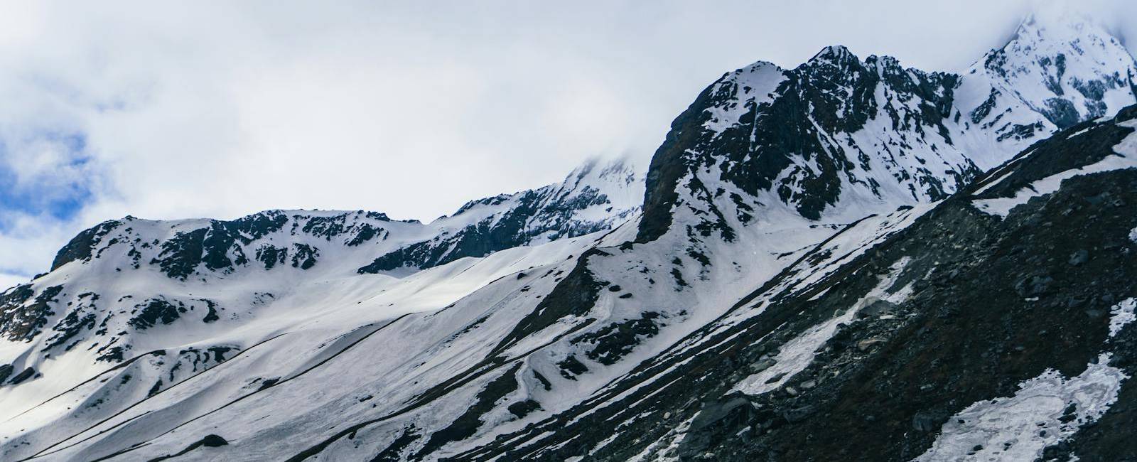
The Guardian Peaks: Mt. Gaurishankar and Melungtse
You cannot discuss the location of Rolwaling without talking about the colossal peaks that form its architectural spine. The valley rests directly under the watchful eye of Mt. Gaurishankar (7,134 m).
Gaurishankar is not just a mountain; it is a spiritual anchor for both Hindus and Buddhists. The mountain has two distinct peaks: the northern peak is identified as Gauri (a manifestation of the goddess Parvati), while the southern peak represents her consort, Shankar (Lord Shiva). For decades, Nepal Standard Time (NST) was precisely calibrated based on the meridian line passing through this exact mountain.
Further north, crossing over the Tibetan border, sits Melungtse (7,181 m), the highest peak of the entire Rolwaling Himal range. Together with dozens of summits exceeding 6,000 meters (such as Chekigo and Yalung Ri), these giants isolate the Rolwaling Valley from the rest of Nepal, creating a unique microclimate and preserving its status as a Beyul - a sacred hidden valley of refuge in Tibetan Buddhist tradition.
What Makes the Rolwaling Valley Trek Unique?
For travelers searching for an authentic, unpasteurized Himalayan experience, the Rolwaling Valley Trek stands completely distinct from mainstream routes.
|
Mainstream Treks (EBC / ABC) |
Rolwaling Valley Trek |
|
Highly Commercialized |
Raw Wilderness & Pristine Trails |
|
Packed Teahouses & Crowded Trail |
Quite Village & Homestay Feel |
|
Westernized Menus & Souvenirs |
Unaltered Sherpa Cultural Heritage |
|
Flight-Dependent (Lukla / etc.) |
Overland Drive Access |
Unspoiled Sherpa and Tamang Culture
Unlike the bustling hubs of Namche Bazaar, the villages of Bedding and Na have retained their traditional structures. The local Sherpa clans (primarily Chusherpa, Ngonba, and Rukpa) live off yak herding, potato farming, and high-altitude mountaineering. The hospitality here isn't transactional; it is genuine, warm, and deeply rooted in Buddhist principles.
The Mystique of the Yeti and Early Exploration
Rolwaling holds a legendary place in mountaineering history. It was right here, in the upper regions of the valley, that British explorer Eric Shipton famously photographed clear Yeti footprints on the Drolambau Glacier during his 1951 reconnaissance expedition. The valley retains that exact sense of frontier exploration to this day.
Standard 10-Day Rolwaling Valley Trek Itinerary
To help you visualize the journey from Kathmandu up into the heart of the valley and back, we utilize a well-paced, safety-conscious itinerary designed for optimal altitude adjustment.
1. Kathmandu to Chhetchhet Drive & Trek to Simigaon
Elevation: 2,000 m | 8-10 hrs drive, 2 hrs hike.
Depart Kathmandu early via private vehicle or local transport, passing through Charikot and Singati to reach Chhetchhet. Cross the suspension bridge over the Tamakoshi River and begin a steep, staircase-like ascent up to the beautiful Tamang ridge village of Simigaon.
2. Simigaon to Dongang
Elevation: 2,790 m | 5-6 hrs hike.
Enter the cool canopy of the Rolwaling River valley. The trail winds through deep rhododendron and bamboo forests, offering occasional glimpses of Gaurishankar before descending slightly to the riverside settlement of Dongang.
3. Dongang to Bedding
Elevation: 3,690 m | 6-7 hrs hike.
A challenging but rewarding day. The trail climbs steadily as the valley begins to transition from sub-alpine forest to a classic, wide U-shaped glacial valley. You will cross several mountain streams before arriving at Bedding, the largest permanent Sherpa settlement in the valley.
4. Acclimatization and Exploration Day in Bedding
Elevation: 3,690 m | Rest & Adaptation.
Crucial day for safety. Take a day hike to a nearby ridge or visit the historic Bedding Monastery, nestled directly against a massive cliff face. This allows your body to adjust to the thinned air before pushing past the 4,000 meter mark.
5. Bedding to Na Village
Elevation: 4,180 m | 4-5 hrs hike.
A short, scenic walk as you ascend above the tree line. The trail passes open alpine pastures populated by grazing yaks. You will arrive at Na Village, a seasonal stone-house settlement situated in an expansive mountain amphitheater, by lunchtime.
6. Excursion to Tsho Rolpa Lake & Return to Na
Elevation: 4,580 m | 5-6 hrs round trip.
The pinnacle of the trek. Hike along the terminal moraine of the Trakarding Glacier to reach the vast, icy expanse of Tsho Rolpa Lake. The views of the surrounding peaks reflecting off the water are unforgettable. After exploring, descend back to Na for the night.
7. Na Village to Dongang
Elevation: 2,790 m | 6-7 hrs hike.
Begin the return journey. Thanks to the descending altitude, gravity is on your side, allowing you to trace your steps back down through Bedding and deep into the forested valley of Dongang.
8. Dongang to Chhetchhet & Drive to Charikot
Elevation: 1,980 m | 5 hrs hike, 2 hrs drive.
Trek back down past Simigaon, descending the final stone steps to the bridge at Chhetchhet. Meet our vehicle for a relaxing short drive up to the hillside town of Charikot to celebrate a successful trek.
9. Charikot to Kathmandu
Elevation: 1,350 m | 6-7 hrs drive.
Enjoy a scenic drive back to the capital city along the highway, reflecting on an off-the-beaten-path adventure that few western travelers ever get to experience.
Essential Logistics: Permits, Weather, and Gear
Planning a journey to a remote location like the Rolwaling Valley requires meticulous preparation. Here is a baseline of what you need to organize before departure.
Permits Required for Rolwaling Valley Trek
Because the trek enters a sensitive border environment and a protected conservation area, you cannot simply show up. You will need:
-
Gaurishankar Conservation Area Permit (GCAP)
-
Trekkers' Information Management Systems (TIMS) Card
Best Time for Rolwaling Valley Trek
Like most of the Nepalese Himalayas, timing your trip around the monsoon is critical for clear views and safe trail conditions.
|
Season |
Months |
Trail Conditions |
Visibility |
|---|---|---|---|
|
Autumn |
Oct-Nov |
Dry, stable trails; crisp air |
Exceptionally clear alpine views |
|
Spring |
Mar-May |
Vibrant blooms of rhododendrons |
Beautiful morning views; occasional afternoon clouds |
|
Winter |
Dec-Feb |
Deep snow locks the upper valley |
Extreme cold; teahouses mostly closed |
|
Monsoon |
Jun-Sep |
High risk of landslides on drive |
Obscured by fog; active leeches on lower trails |
Frequently Asked Questions (FAQ)
Where is Rolwaling Valley located exactly within Nepal?
Rolwaling Valley is located in east-central Nepal within the Dolakha District (Bagmati Province), positioned right between Langtang National Park to the west and the Khumbu (Everest) region to the east.
How difficult is the Rolwaling Valley Trek?
The trek is graded as moderate to challenging. While reaching Tsho Rolpa Lake (4,580 m) requires good physical fitness and stamina for long, steep ascents, it does not require technical mountaineering skills. However, if you choose to extend the trek over the Tashi Lapcha Pass (5,755 m) into the Everest region, it becomes a highly technical mountaineering expedition requiring ropes, ice axes, and crampons.
Are there teahouses available on the Rolwaling route?
Yes, basic teahouse facilities are available up to Bedding and Na Village. While they are far more rustic and simple compared to the luxury lodges found on the Everest Base Camp trail, they provide cozy beds, warm blankets, and hearty, home-cooked local meals like Dal Bhat, Sherpa stew, and potato dishes.
Can I do the Rolwaling Valley Trek solo or independently?
While technically possible for the lower section to Tsho Rolpa, it is highly discouraged. The trails are remote, medical facilities are non-existent past Charikot, and English is rarely spoken in the upper villages. To guarantee your safety, navigate complex permit regulations, and truly connect with the local culture, traveling with a registered local guide is strongly recommended.
Conclusion
The Rolwaling Valley remains one of the last true wild frontiers of Nepalese trekking - a place where geography has successfully defended culture and nature from the footprints of mass commercialization. Finding where it is located is just the first step; stepping foot onto its steep paths is what changes you forever.
As you plan your journey into this breathtaking, hidden Himalayan sanctuary, having a trusted partner with deep local roots makes all the difference. We at Best Heritage Tour specialize in crafting authentic, safe, and deeply immersive cultural and adventure expeditions throughout the Gaurishankar region.
For customized itineraries, booking inquiries, or to speak directly with a Himalayan destination specialist, reach out to us:
Phone / WhatsApp / Viber: +977-9851149197 / +977-9810043046
Email: info@bestheritagetour.com / bestheritagetour@gmail.com
Website: www.bestheritagetour.com
Office: Thamel Marg, Kathmandu, Nepal
Author: Best Heritage Tour
Date: 30th June, 2026