Dhaulagiri Circuit Trek Itinerary
For adventurers who find the classic tea-house trails of Nepal a bit too crowded, the wild, raw, and untamed terrain of Western Nepal calls. If your dream adventure involves traversing high-altitude glaciers, standing face-to-face with an 8,000-meter giant, and crossing high mountain passes where the only tracks in the snow belong to wildlife and fellow expedition members, then the Dhaulagiri Circuit Trek is your ultimate calling.
At Best Heritage Tour, we have spent decades guiding bold explorers through the most remote corners of the Himalayas. We don't just see this route as a path on a map; it is a profound journey through dramatic climate zones, isolated ethnic settlements, and high-altitude wilderness.
This comprehensive, highly detailed Dhaulagiri Circuit Trek Itinerary provides the exact logistical blueprints, elevation profiles, and safety insights needed to conquer one of the most demanding and rewarding loops in the entire Himalayan mountain range.
Why Choose the Dhaulagiri Circuit Trek?
Mount Dhaulagiri (8,167 m / 26,795 ft) is the seventh highest mountain in the world. Its name, derived from the Sanskrit words Dhavala (white) and Giri (mountain), perfectly encapsulates its dazzling, icy presence over the deep Kali Gandaki Gorge.
Unlike the classic Annapurna Circuit or Everest Base Camp routes, the Dhaulagiri loop is a true wilderness expedition. A significant portion of the trail cuts through uninhabited alpine territory, requiring specialized camping logistics, self-sufficiency, and experienced mountain guides.
Quick Trip Overview
-
Total Duration: 16 Days (Kathmandu to Kathmandu)
-
Maximum Elevation: 5,360 m / 17,585 ft (French Pass)
-
Trek Grade: Challenging / Expedition Level
-
Accommodation: Teahouses (initial and final days) and high-altitude alpine camping (middle days)
-
Best Seasons: Autumn (September to November) and Spring (March to May)
The Definitive 16-Day Dhaulagiri Circuit Trek Itinerary
This Updated Dhaulagiri Circuit Trek Itinerary is engineered by our team of senior mountain guides to ensure proper, safe acclimatization. Rushing this specific route is highly dangerous due to the rapid ascent into the glacier zones. Below is the day-by-day blueprint for your expedition.
Day 1: Drive from Kathmandu to Beni
Elevation: 1,400m to 830m | Drive Time: 8-9 hours.
Our journey begins early in the morning as our team picks you up from your hotel in Kathmandu. We embark on a long, scenic drive westward along the Prithvi Highway, tracing the raging waters of the Trishuli and Marsyangdi rivers. After passing through the lakeside city of Pokhara, we continue onward along the highway to Beni, the administrative headquarters of the Myagdi District. This bustling riverside town sits at the confluence of the Myagdi Khola and Kali Gandaki River, serving as the official gateway to our off-the-beaten-path adventure. We spend the night in a local guesthouse, resting up for the foot journey ahead.
Day 2: Trek from Beni to Dharapani
Elevation: 830m to 1,560m | Trek Time: 5-6 hours.
Lacing up our boots for the first official trekking day, we bid farewell to the motorable road and follow the trail running parallel to the Myagdi Khola. The route leads us through lush, subtropical terraced fields, vibrant green forests, and small, traditional hamlets inhabited by the Magar and Gurung communities. We pass through villages like Singa and Tatopani (not to be confused with the Annapurna Tatopani) before making a gradual climb up to Dharapani. This beautiful village offers us our very first glimpses of the stunning Dhaulagiri Himal range on a clear day.
Day 3: Trek from Dharapani to Jhukepani
Elevation: 1,560m to 1,850m | Trek Time: 5-6 hours.
Leaving Dharapani, the trail winds smoothly through changing landscapes as we deep-dive into the rural heart of Nepal. We cross several suspension bridges slung over rushing tributaries, listening to the roar of the Myagdi Khola below. The path alternates between gentle ridges and short, steep stone staircases, passing through clean settlement outposts. As we reach Jhukepani, the air grows noticeably crisper, and the warmth of the lower valleys begins to transition into cooler mountain air. Tonight is spent in a cozy, rustic teahouse environment.
Day 4: Trek from Jhukepani to Boghara Village
Elevation: 1,850m to 2,080m | Trek Time: 5-6 hours.
Today's trek introduces us to more rugged terrain. We ascend steadily along the river valley, passing through the small settlement of Muri before descending briefly to the streams and crossing over. From here, a steep, challenging climb up a stone staircase tests our leg endurance before leveling out on a high trail that leads directly into Boghara Village. Boghara is one of the last permanently inhabited, traditional villages on this side of the circuit, offering a fascinating glimpse into remote mountain farming practices.
Day 5: Trek from Boghara to Dobang
Elevation: 2,080m to 2,520m | Trek Time: 6-7 hours.
As we leave Boghara, human settlements grow sparse, and the wild side of the trek truly takes over. The trail descends through terraced fields before plunging into dense, mystical bamboo, oak, and rhododendron forests. This section can be muddy and wild, with exposed roots and narrow paths running along the canyon walls. We cross the Myagdi Khola via a wooden bridge and climb steadily through the forest shadows until we open up into Dobang, a small forest clearing containing rudimentary summer shelters used by local herders.
Day 6: Trek from Dobang to Choriban Khola
Elevation: 2,520m to 3,110m | Trek Time: 5-6 hours.
The trail continues to carve its way deeper into the dense, uninhabited jungle terrain. Today, we cross a wooden bridge over the Konaban Khola and catch incredible, towering glimpses of the West Face of Dhaulagiri rising majestically through the tree canopy. The climb is a steady, relentless upward push as the forest begins to thin out, making way for sub-alpine shrubs and alpine meadows. We set up our campsite at Choriban Khola, a remote alpine clearing, marking the definitive transition from lodge-to-lodge trekking to fully supported wilderness camping.
Day 7: Trek from Choriban Khola to Italian Base Camp
Elevation: 3,110m to 3,660m | Trek Time: 4-5 hours.
Today is a shorter but highly important trekking day as we ascend past the 3,500 m threshold. We trace the lateral moraine of the Chhonbardan Glacier, navigating through rugged rocks and scree slopes. The valley widens out significantly, revealing a dramatic alpine amphitheater. We reach the famous Italian Base Camp, named after an early Italian mountaineering expedition. Located directly at the foot of Dhaulagiri's massive, sheer West Face, the views from this campsite are jaw-dropping.
Day 8: Rest and Acclimatization Day at Italian Base Camp
Elevation: 3,660m | Full Rest Day.
Acclimatization is not an option; it is an absolute safety requirement on this route. At Best Heritage Tour, our itineraries strictly enforce a rest day here before entering the high glacier zone. You can spend the day resting inside your tents, organizing gear, or taking short, gentle day hikes up the nearby ridges to help your body adapt to the thinner air. Staying well-hydrated and letting your red blood cells multiply today is key to successfully crossing the high passes ahead.
Day 9: Trek from Italian Base Camp to Glacier Camp
Elevation: 3,660m to 4,210m | Trek Time: 5-6 hours.
This is one of the most thrilling and adventurous days of the entire loop. We navigate through a narrow, steep gorge known as the "French Chute," a zone highly prone to rockfall and avalanches from the surrounding peaks. Our guides lead the way with extreme caution, navigating across the ice and rock debris of the glacier itself. After a steep scramble up the terminal moraine, we arrive at Glacier Camp, an otherworldly campsite pitched directly on the moraine debris over a solid ice foundation.
Day 10: Trek from Glacier Camp to Dhaulagiri Base Camp
Elevation: 4,210m to 4,740m | Trek Time: 4-5 hours.
We follow the rough, undulating surface of the Chhonbardan Glacier, walking directly over a landscape of ice, lateral moraines, and frozen glacial ponds. The walking can be slow and tiring due to the high altitude and unstable rubble underfoot. As we approach Dhaulagiri Base Camp (DBC), the spectacular North Face of Dhaulagiri I dominates the entire sky. Surrounding us are Dhaulagiri II, III, and V, creating a staggering ring of ice and rock. We camp tonight surrounded by classic mountaineering history, right on the active glacier.
Day 11: Trek from Dhaulagiri Base Camp to Hidden Valley via French Pass
Elevation: 4,740m to 5,100m via 5,360m | Trek Time: 7-8 hours.
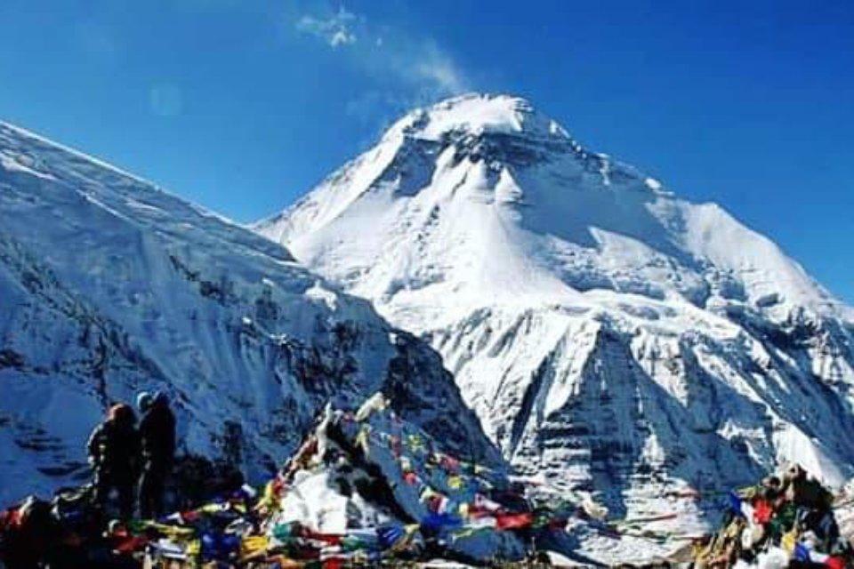
The undisputed climax of our expedition. We wake up long before dawn, layering up against the biting sub-zero temperatures. The trail climbs steeply up the lateral moraine to reach the crest of the French Pass (5,360 m / 17,585 ft). Reaching the top, decorated with colorful fluttering prayer flags, rewards you with a panoramic view of the entire hidden mountain wilderness. From the pass, we descend smoothly into the desolate, wind-swept landscape of the Hidden Valley, a high-altitude sanctuary reminiscent of the Tibetan plateau, where we set up camp at 5,100 m.
Day 12: Trek from Hidden Valley to Kalapani
Elevation: 5,100m to lower valleys | Trek Time: 6-7 hours.
Leaving the wind-battered expanses of the Hidden Valley behind, we navigate our way out across demanding terrain. The trail leads across high alpine flats and around rugged mountain spurs, giving us dramatic views of the transition between the barren rain shadow zones and the deep valleys below. We steadily drop altitude, leaving the permanent ice and snow behind as we make our way toward the settlement areas around Kalapani, stepping back into relative comfort.
Day 13: Trek from Kalapani to Yak Kharka
Elevation: Valley descent to high pasture | Trek Time: 5-6 hours.
Today we move through alpine pastures used by local mountain dwellers to graze their herds during the summer months. The route treats us to expansive, open-air views of the Annapurna Massif directly across the deep Kali Gandaki chasm. We navigate winding trails flanked by hardy alpine scrub, arriving at Yak Kharka to pitch our tents or stay in seasonal shelters, enjoying a spectacular mountain sunset.
Day 14: Trek from Yak Kharka to Marpha
Elevation: Descent to 2,670m | Trek Time: 4-5 hours.
A beautiful, long, steep descent brings us down into the world-famous Kali Gandaki Valley. The terrain changes dramatically into an arid, desert-like pine environment as we arrive in Marpha. Famed for its pristine white-washed stone houses, neat stone-paved alleys, and sprawling apple orchards, Marpha feels like an oasis. Celebrate the successful completion of the foot journey with a glass of local apple brandy or freshly baked apple pie!
Day 15: Drive from Marpha to Pokhara
Elevation: 2,670m to 822m | Drive Time: 6-7 hours.
We board our private vehicle and embark on an adventure-filled drive down through the deepest gorge in the world, the Kali Gandaki. The road winds past stunning waterfalls, sheer cliff faces, and transition zones from high-altitude desert to lush subtropical greenery. By late afternoon, we arrive back in the vibrant, relaxing lakeside city of Pokhara, where hot showers, comfortable hotel beds, and lakeside restaurants await us.
Day 16: Drive or Flight from Pokhara to Kathmandu
Elevation: Return to 1,400m | Travel Time: 30-min flight or 6-7 hour drive.
Depending on your chosen travel package with us, you will either board a short, highly scenic 30-minute flight along the Himalayan range or enjoy a comfortable private drive back to Kathmandu. Upon arriving in the capital, our team transfers you directly back to your hotel, marking the official conclusion of an unforgettable mountain expedition.
Essential Packing and Preparation Checklist for Dhaulagiri Circuit Trek
To safely manage the extreme conditions encountered on this route, your gear needs to be top-tier:
-
Footwear: Sturdy, well-insulated, high-ankle trekking boots (fully broken-in) paired with multiple pairs of merino wool socks.
-
Sleeping Systems: A four-season sleeping bag rated down to at least -15℃ to -20℃ (5℉ to -4℉), plus an insulated sleeping pad for glacier camping.
-
Layering: High-quality down jacket, windproof and waterproof outer shells, thermal base layers, and fleece mid-layers.
-
Hardware: Heavy-duty trekking poles, UV-protection sunglasses (essential for glacier reflection), and a high-lumens headlamp with extra batteries.
Frequently Asked Questions (FAQ)
Do I need crampons or technical climbing gear for the French Pass?
Generally, for standard trekking seasons, technical climbing gear like ropes and harnesses is not required. However, micro-spikes or lightweight crampons are highly recommended, as you will be walking directly over glacier ice and potentially slick snow on the approach to the French Pass.
What permits are required for the Dhaulagiri Circuit Trek?
You will need two primary permits: the Annapurna Conservation Area Project (ACAP) permit and the Trekkers' Information Management Systems (TIMS) card. Our administrative team handles all of these clearances seamlessly prior to your arrival in Kathmandu.
Is communication available on the Dhaulagiri Circuit Trek trail?
Cellular networks (Ncell/Nepal Telecom) work reasonably well during the first few days and the final days near Marpha. However, throughout the wilderness block from Dobang to Yak Kharka, there is absolutely zero cellular reception. Our guiding team carries satellite communication devices and emergency radios for absolute safety.
Conclusion
Conquering the wild ridges, frozen glaciers, and high mountain passes of the Dhaulagiri Circuit Trek Itinerary is a milestone achievement that only a handful of global adventurers can claim. It is a journey that demands respect, meticulous logistical planning, and an unwavering spirit of adventure. As you plan your ultimate off-the-beaten-path expedition, having a trusted, experienced, and deeply knowledgeable local partner makes all the difference between a stressful ordeal and the adventure of a lifetime.
At Best Heritage Tour, we handle every single detail of your journey - from securing specialized high-altitude permits and providing premium expedition camping gear to pairing you with veteran, safety-first Himalayan guides. We ensure that your footprints across the Chhonbardan Glacier and over the French Pass are backed by the finest safety protocols and authentic local hospitality in Nepal.
Get in Touch with Best Heritage Tour
Phone / WhatsApp / Viber: +977-9851149197 / +977-9810043046
Email: [email protected] / [email protected]
Website: www.bestheritagetour.com
Office: Thamel Marg, Kathmandu, Nepal