Are you a seasoned trekker seeking a raw, high-altitude challenge in the Annapurna region that steers clear of the commercial crowds? While the classic Thorong La Pass remains a bucket-list achievement, those craving true Himalayan isolation and rugged terrain are turning their eyes toward a different gateway. Welcome to the Mesokanto La Pass trek in 2026 and 2027 - a pristine, demanding, and utterly breathtaking alternative that connects the alpine valleys of Manang with the windswept landscapes of Mustang.
At Best Heritage Tour, we have guided hundreds of adventurers through the diverse ecosystems of Nepal. Lately, our expedition leaders have noticed a massive shift: modern trekkers want fewer teahouses, more raw nature, and trails that test their limits. The Mesokanto La Pass (5,121m / 16,801ft) delivers exactly that.
In this comprehensive guide, we break down the definitive Mesokanto La Pass trek Itinerary, answer critical logistical questions, and provide the expert insights our company is known for to help you plan your ultimate adventure.
Why Choose the Mesokanto La Pass Over Thorong La?
For decades, the Annapurna Circuit has been celebrated worldwide. However, increased road construction has altered portions of the classic route. The Mesokanto La Pass detour bypasses the standard path after Manang, pulling you deep into the wilderness surrounding the legendary Tilicho Lake - one of the highest lakes in the world.
Unlike Thorong La, which features a wide, well-trodden path, Mesokanto La is a technical, steep, and often snow-covered crossing. It demands proper acclimatization, precise navigation, and an adventurous spirit. When you trek with us, you aren't just taking a vacation; you are embarking on a fully supported expedition through a remote mountain wilderness.
At a Glance: Trek Vital Statistics
Before diving into the day-by-day breakdown, let’s look at the quick facts for planning your trip.
|
Metric / Feature |
Details |
|---|---|
|
Total Duration |
12 Days (Kathmandu to Kathmandu) |
|
Maximum Altitude |
5,121 meters / 16,801 feet (Mesokanto La Pass) |
|
Trek Difficulty |
Strenuous / Demanding |
|
Best Seasons |
Spring (March to May) & Autumn (September to November) |
|
Permits Required |
ACAP (Annapurna Conservation Area Permit) & TIMS Card |
|
Accommodation |
Teahouses (Days 1-7, 10-11) & High-Altitude Camps/Basic Lodges (Days 8-9) |
How Difficult is the Mesokanto La Pass?
A question our team gets asked almost daily is: How difficult is the Mesokanto La Pass?
To give you an honest, professional assessment: this trek is classified as strenuous. It is considerably more challenging than the standard Annapurna Circuit. Here is why:
-
Steep Incline and Decline: The ascent to the pass from Tilicho High Camp involves navigating loose scree, moraine, and frequently hard-packed snow or ice. The descent toward Jomsom is notoriously steep and requires stable footwork and trekking poles.
-
Altitude and Exposure: Spending multiple days above 4,000 meters, with the pass itself crossing the 5,100-meter threshold, puts a heavy demand on your cardiovascular system.
-
Weather Volatility: At 5,121 meters, the weather can change in minutes. High winds, sudden snowfall, and dropping temperatures are common, requiring experienced guides who can read the mountain conditions safely.
For a successful crossing, our team highly recommends previous high-altitude trekking experience, excellent physical cardio conditioning, and a mentality ready for the elements.
The Definitive 12-Day Mesokanto La Pass Trek Itinerary
This itinerary has been meticulously crafted by our expert route planners to ensure optimal acclimatization, minimizing the risk of Acute Mountain Sickness (AMS) while maximizing your time in the wilderness.
Day 1: Drive from Kathmandu (1,350m / 4,429ft) to Besisahar (760m / 2,493ft) then to Chame (2,670m / 8,760ft)
Our journey begins early in the morning. We depart from Kathmandu in a private four-wheel-drive vehicle, tracing the winding Prithvi Highway alongside the Trishuli River. After reaching the bustling hub of Besisahar, the tarmac gives way to an adventurous off-road track.
As we drive alongside the Marsyangdi River, watch the landscape shift drastically from subtropical terraced rice fields to dramatic vertical cliffs and cascading waterfalls. By evening, we arrive in Chame, the administrative headquarters of the Manang district. Here, we catch our first stunning views of Annapurna II and Lamjung Himal.
Day 2: Trek from Chame (2,670m / 8,760ft) to Pisang (3,200m / 10,498ft)
-
Trek Duration: 5-6 hours
-
Landscape: Pine forests, apple orchards, and sheer rock walls
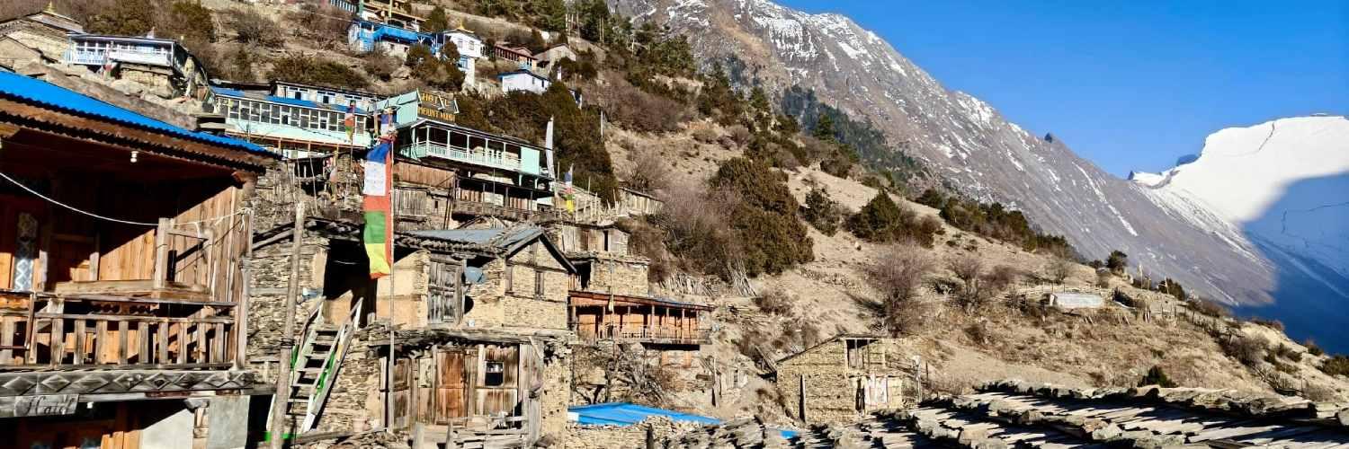
We lace up our boots for our first official day on the trail. Walking through dense pine forests, we pass the iconic Paungda Danda - a massive, smooth rock face that curves dramatically upward out of the river, rising over 1,500 meters. The local communities revere this geological wonder as the "Gateway to Heaven." As we cross the threshold into Upper Manang, the air grows crisp and thin, bringing us into the scenic, culturally rich village of Pisang.
Day 3: Trek from Pisang (3,200m / 10,498ft) to Manang (3,540m / 11,614ft)
-
Trek Duration: 6-7 hours
-
Landscape: Semi-arid alpine desert with panoramic mountain views
Today, we opt for the upper route via Ghyaru and Ngawal. While it is physically more demanding, our guides favor this path because the extra elevation gains are perfect for active acclimatization.
The upper trail offers sweeping, unobstructed views of Annapurna II, III, IV, Gangapurna, and Tilicho Peak. We pass ancient Tibetan-style stone villages and spinning prayer wheels before descending into the broad valley floor of Manang, our home for the next two nights.
Day 4: Rest and Acclimatization at Manang (3,540m / 11,614ft)
Skipping an acclimatization day in Manang is a critical mistake we never let our guests make. Today is dedicated to helping your body adjust to the thin air.
Our team will lead you on a short hike up to Gangapurna Lake or the viewpoint near the Vriga Monastery. The rest of the afternoon is yours to enjoy - sip a warm coffee at a local bakery, watch an afternoon documentary presentation on altitude safety, or explore the historic, narrow stone alleys of old Manang.
Day 5: Trek from Manang (3,540m / 11,614ft) to Shree Kharka (4,060m / 13,320ft)
-
Trek Duration: 4-5 hours
-
Landscape: Rugged paths, juniper bushes, and wilderness gorges
Leaving the main Annapurna Circuit trail behind, we split off toward the western wilderness. The path takes us down toward the river before climbing steadily toward Khangsar. We push past this last permanent settlement and continue upward to Shree Kharka. The views of the surrounding peaks feel closer and more imposing than ever, setting a true backcountry mood.
Day 6: Trek from Shree Kharka (4,060m / 13,320ft) to Tilicho Base Camp (4,150m / 13,615ft)
-
Trek Duration: 4-5 hours
-
Landscape: Steep scree slopes and dramatic landslide zones
Today’s trek is relatively short in distance but demands absolute focus. We navigate the infamous "Landslide Area," a narrow trail carved into steep slopes of loose gravel and shale. Our expert guides will lead the way, keeping a sharp eye on the cliffs above and ensuring the team moves safely across.
The reward at the end of the day is reaching Tilicho Base Camp, a modest settlement tucked into a stark, awe-inspiring glacial amphitheater.
Day 7: Rest and Acclimatization at Tilicho Base Camp with visit to Tilicho Lake (4,919m / 16,138ft)
-
Trek Duration: 5-6 hours (round trip to the lake)
-
Landscape: Glacial moraines, vast ice sheets, and deep blue alpine water
We set off before dawn, climbing a series of steep switchbacks. As the sun rises, the jaw-dropping expanse of Tilicho Lake reveals itself. Nestled against the massive Tilicho Peak, the lake's brilliant turquoise water shifts tones in the morning light.
Spending time at 4,919 meters provides the final boost your body needs for the pass. After taking photos and soaking in the views, we head back down to Tilicho Base Camp for a warm meal and a restful afternoon.
Day 8: Trek from Tilicho Base Camp (4,150m / 13,615ft) to Tilicho High Camp (4,900m / 16,076ft)
-
Trek Duration: 4 hours
-
Landscape: High alpine tundra and rocky slopes
Today we leave the standard trails completely behind. We ascend toward Tilicho High Camp (sometimes referred to as Mesokanto Base Camp). The path is rugged and untamed.
Accommodations up here are very basic, often requiring a wilderness camp setup depending on seasonal conditions. Our crew takes extra care to ensure everyone stays well-hydrated, warm, and ready for the big push tomorrow.
Day 9: Cross Mesokanto La Pass (5,121m / 16,801ft) and descend to Yak Kharka (4,200m / 13,779ft)
-
Trek Duration: 7-9 hours
-
Landscape: Snowfields, exposed ridges, and a dramatic drop into the dry Mustang terrain
This is the defining day of our expedition. Starting in the freezing, dark hours of the early morning, we slowly work our way up to the summit of the Mesokanto La Pass at 5,121 meters. Reaching the top reveals an unforgettable panoramic reward. To your east sits the frozen expanse of Tilicho; to your west, the immense Dhaulagiri massif dominates the sky, looking out over the deep Kali Gandaki Gorge.
After celebrating at the top, we begin a long, steep descent. The landscape transforms around us as we leave the snow behind and enter the arid, desert-like hills of the Mustang region, finally resting our tired feet at the seasonal settlement of Yak Kharka.
Day 10: Trek from Yak Kharka (4,200m / 13,779ft) to Jomsom (2,720m / 8,924ft)
-
Trek Duration: 4-5 hours
-
Landscape: Arid canyons, apple orchards, and wide gravel riverbeds
Our path snakes downward through unique rock formations, offering views of Thinigaon and the sprawling Kali Gandaki valley. As we arrive in Jomsom, the sudden return of running water, hot showers, and Wi-Fi feels like absolute luxury. In the evening, we gather with our guides and porters to share a celebratory dinner, enjoying local Marpha apple brandy to toast a successful crossing.
Day 11: Drive from Jomsom (2,720m / 8,924ft) to Pokhara (822m / 2,697ft)
We trade our trekking boots for a private vehicle and begin the journey down the mountain. The drive follows the Kali Gandaki highway, passing through Tatopani (famous for its natural hot springs) and deep valley gorges before entering the lush, subtropical climate of Pokhara. Spend your evening relaxing by the shores of Fewa Lake, looking back up at the Annapurna range you just successfully bypassed.
Day 12: Drive from Pokhara (822m / 2,697ft) to Kathmandu (1,350m / 4,429ft)
On our final day, we drive back to Kathmandu along the scenic Prithvi Highway. Watch the rural villages and rushing rivers pass by one last time before returning to the capital city, marking the end of an incredible Himalayan wilderness adventure.
Essential Packing List and Gear Guide
Because of the unpredictable weather at Tilicho High Camp and the pass, your gear choice is critical. Here is a baseline list of essentials our team recommends:
-
Footwear: Broken-in, waterproof trekking boots with deep ankle support, alongside microspikes (crampons) for crossing icy sections on the pass.
-
Layering System: Merino wool thermal base layers, a thick fleece mid-layer, a windproof/waterproof hard shell, and a high-fill down jacket graded for down to -15°C.
-
Gear: A four-season sleeping bag, sturdy trekking poles (essential for the steep descent to Jomsom), and high-UV protection sunglasses to prevent snow blindness.
-
Safety: A personal first-aid kit containing Acetazolamide (Diamox) for altitude, water purification tablets, and a reliable headlamp with extra batteries for the summit push.
Conclusion
The Mesokanto La Pass trek is far more than a simple mountain walk; it is a true backcountry expedition that shows you the rawest side of the Annapurna and Mustang regions. From the turquoise waters of Tilicho Lake to the high-altitude challenges of the 5,121-meter pass, this journey promises memories that will last a lifetime.
Planning a remote trek like this requires careful logistics, reliable safety support, and experienced local leadership. At Best Heritage Tour, we handle every detail - from securing your permits and arranging safe, private transport to providing expert guides who prioritize your safety and comfort every step of the way. Let us take care of the logistics while you focus on the journey.
Connect With Our Travel Experts
Phone / WhatsApp / Viber: +977-9851149197 / +977-9810043046
Email: info@bestheritagetour.com / bestheritagetour@gmail.com
Website: www.bestheritagetour.com
Office: Thamel Marg, Kathmandu, Nepal
Author: Best Heritage Tour
Date: 17th May, 2026